IMAGES TAKEN NEAR TO
Tone Close, NEWPORT, NP20 7AT
Introduction
This page details the photographs taken nearby to Tone Close, NP20 7AT by members of the Geograph project.
The Geograph project started in 2005 with the aim of publishing, organising and preserving representative images for every square kilometre of Great Britain, Ireland and the Isle of Man.

There are currently over 7.5m images from over14,400 individuals and you can help contribute to the project by visiting https://www.geograph.org.uk
Image Map
Images are licensed for reuse under creativecommons.org/licenses/by-sa/2.0
Notes
- Clicking on the map will re-center to the selected point.
- The higher the marker number, the further away the image location is from the centre of the postcode.
Image Listing (164 Images Found)
Images are licensed for reuse under creativecommons.org/licenses/by-sa/2.0
Image
Details
Distance
1
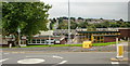
Bettws Health Centre, Newport
This part of Bettws is set below the level of the south side of Monnow Way, next to Lambourne Way. It contains a library, post office, pub, police station and health centre. Bettws Health Centre is in the left centre of the photo, next to the tree.
Image: © Jaggery
Taken: 31 Aug 2009
0.02 miles
2
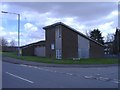
United Reformed Church, Bettws
On the corner of Tone Close.
Image: © Roger Cornfoot
Taken: 1 Mar 2007
0.03 miles
3

Bettws Post Office, Newport
Occupying units 12 and 13 in Bettws Shopping Centre.
Image: © Jaggery
Taken: 29 Feb 2016
0.03 miles
4
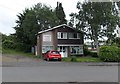
St David's Church House in Bettws, Newport
Located in Tone Close, on the south side of Monnow Way.
Image: © Jaggery
Taken: 29 May 2014
0.03 miles
5
World Trade Centre Memorial Garden in Bettws Shopping Centre, Newport
The inscription on the plaque http://www.geograph.org.uk/photo/4849112 on the garden wall is
THIS GARDEN IS DEDICATED TO THE MEMORY OF ALL THOSE WHO LOST THEIR LIVES AT THE WORLD TRADE CENTRE NEW YORK SEPTEMBER 11TH 2001.
The Memorial Garden is the location of the annual Memorial Service remembering the terrorist atrocities of September 11th 2001, perpetrated by the terrorist group Al-Qaeda which hijacked passenger airliners, targeting them to hit the World Trade Centre in New York City and the Pentagon in Washington DC. One plane crashed into a Pennsylvania field. Nearly 3,000 people were killed in total.
The annual Memorial Service also remembers the service personnel killed in later conflicts.
Image: © Jaggery
Taken: 29 Feb 2016
0.04 miles
6
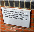
World Trade Centre Memorial Garden plaque, Bettws Shopping Centre, Newport
The plaque is on the wall here. http://www.geograph.org.uk/photo/4849097
Image: © Jaggery
Taken: 29 Feb 2016
0.04 miles
7

Queen Elizabeth II pillarbox outside Bettws Post Office, Newport
Located here. http://www.geograph.org.uk/photo/4880460
Image: © Jaggery
Taken: 29 Feb 2016
0.04 miles
8
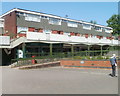
Bettws post office, Newport
Located on the west side of Bettws shopping centre. The post office was formerly in this building http://www.geograph.org.uk/photo/2398796 nearby, now the police station.
Image: © Jaggery
Taken: 28 Apr 2011
0.04 miles
9

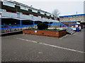
Spar, Bettws, Newport
Located in the shopping centre on the west side of Lambourne Way.
Image: © Jaggery
Taken: 28 Apr 2011
0.04 miles
10
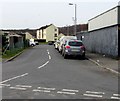
Unnamed side road, Bettws, Newport
On the west side of Lambourne Way, at the southern edge of Bettws Shopping Centre.
Several of the parked vehicles are police vehicles. http://www.geograph.org.uk/photo/4847908 Bettws Police Station is nearby. http://www.geograph.org.uk/photo/4848862
Image: © Jaggery
Taken: 29 Feb 2016
0.04 miles