IMAGES TAKEN NEAR TO
Trent Road, NEWPORT, NP20 7AJ
Introduction
This page details the photographs taken nearby to Trent Road, NP20 7AJ by members of the Geograph project.
The Geograph project started in 2005 with the aim of publishing, organising and preserving representative images for every square kilometre of Great Britain, Ireland and the Isle of Man.

There are currently over 7.5m images from over14,400 individuals and you can help contribute to the project by visiting https://www.geograph.org.uk
Image Map
Images are licensed for reuse under creativecommons.org/licenses/by-sa/2.0
Notes
- Clicking on the map will re-center to the selected point.
- The higher the marker number, the further away the image location is from the centre of the postcode.
Image Listing (152 Images Found)
Images are licensed for reuse under creativecommons.org/licenses/by-sa/2.0
Image
Details
Distance
1
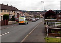
Exe Road, Bettws, Newport
Viewed across Monnow Way.
Image: © Jaggery
Taken: 29 May 2014
0.04 miles
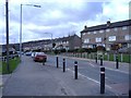
3
Rother Close, Bettws, Newport
Access to this side of Rother Close is via paths from Leach Road.
Vehicular access is from Trent Road on the far side.
Image: © Jaggery
Taken: 29 May 2014
0.04 miles
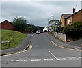
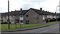
4
Trent Road, Bettws, Newport
Viewed from the Leach Road end looking along Trent Road towards Exe Road.
Image: © Jaggery
Taken: 29 May 2014
0.06 miles
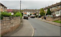
5

Path to Trent Road, Bettws, Newport
From the north side of Monnow Way.
Image: © Jaggery
Taken: 29 May 2014
0.07 miles
6
Police van in Medway Road, Bettws, Newport
Viewed from the corner of Leach Road.
Image: © Jaggery
Taken: 29 May 2014
0.08 miles
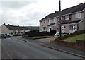
7
Tone Road, Bettws, Newport
From Tone Close.
Image: © Jaggery
Taken: 29 May 2014
0.08 miles
8
Itchen Close, Bettws, Newport
Viewed from Itchen Road.
Image: © Jaggery
Taken: 31 Aug 2009
0.09 miles
9
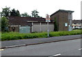
Derelict former church in Bettws, Newport
This is the north side of the former Bettws Free Church United Reformed, viewed across Monnow Way. The church opened for worship in 1964. It closed down several years ago and is slowly decaying.
Viewed in late May 2014.
Image: © Jaggery
Taken: 29 May 2014
0.10 miles
10
West side of a long derelict church building in Bettws, Newport
On the corner of Monnow Way and Tone Close. In late May 2014, though the nameboard shows Bettws Free Church United Reformed, it is several years since the slowly decaying building was in use.
The church opened for worship in 1964.
Image: © Jaggery
Taken: 29 May 2014
0.10 miles