IMAGES TAKEN NEAR TO
Rowan Way, NEWPORT, NP20 6WS
Introduction
This page details the photographs taken nearby to Rowan Way, NP20 6WS by members of the Geograph project.
The Geograph project started in 2005 with the aim of publishing, organising and preserving representative images for every square kilometre of Great Britain, Ireland and the Isle of Man.

There are currently over 7.5m images from over14,400 individuals and you can help contribute to the project by visiting https://www.geograph.org.uk
Image Map
Images are licensed for reuse under creativecommons.org/licenses/by-sa/2.0
Notes
- Clicking on the map will re-center to the selected point.
- The higher the marker number, the further away the image location is from the centre of the postcode.
Image Listing (2328 Images Found)
Images are licensed for reuse under creativecommons.org/licenses/by-sa/2.0
Image
Details
Distance
1
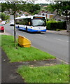
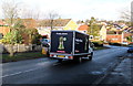
Tesco Free Bus in Malpas, Newport
At 10.26am, a NAT (New Adventure Travel) Scania bus ascends Rowan Way en route to the Tesco superstore in Newport Retail Park. This free bus services operates once a week on Tuesday mornings. The bus returns to this area about two hours later. The free service was formerly run by Newport Bus.
Image: © Jaggery
Taken: 12 Jul 2016
0.01 miles
2
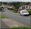
Little Mill Services van parked in Rowan Way, Malpas, Newport
Electrical engineering contractor Little Mill Services Ltd is based in Springvale Industrial Estate, Cwmbran.
Image: © Jaggery
Taken: 15 Jul 2017
0.01 miles
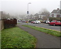
3

Into the fog, Rowan Way, Malpas, Newport
Poor visibility at 12:40pm on January 7th 2021.
Image: © Jaggery
Taken: 7 Jan 2021
0.01 miles
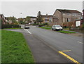
4

Rowan Way roadworks, Malpas, Newport
Viewed from the corner of Laurel Crescent in early January 2016.
There are two logos on the van - Amey and Welsh Water.
Amey is an infrastructure support service provider founded by William Amey in 1921.
Image: © Jaggery
Taken: 5 Jan 2016
0.01 miles
5
April fog in Rowan Way, Malpas, Newport
Viewed from the corner of Pillmawr Road at 8:39am BST (British Summer Time) on April 13th 2016 when visibility is about 100 metres. The Met Office website states that the official definition of fog is a visibility of less than 1,000 metres. This limit is appropriate for aviation purposes, but for the general public and motorists an upper limit of 200 metres is more realistic. Severe disruption to transport occurs when the visibility falls below 50 metres.
Image: © Jaggery
Taken: 13 Apr 2016
0.01 miles
6
Rowan Way bus route, Malpas, Newport
This route has had many variations in frequency of buses in recent years. In October 2018, the uphill route is part of Newport Bus Route 18. The downhill route is part of Newport Bus Route 17. Both routes start from and end at Friars Walk bus station in the city centre. In the evening and on Sunday the uphill route is part of Newport Bus Route 19E. There are no buses on the downhill route in the evening and on Sunday.
Image: © Jaggery
Taken: 12 Oct 2018
0.01 miles
7
Freshly clicked in Rowan Way, Malpas, Newport
A Tesco home delivery van descends Rowan Way.
Image: © Jaggery
Taken: 29 Jan 2015
0.01 miles
8

Dawn view south up Rowan Way, Malpas, Newport
Viewed at 8:15am, local sunrise today, December 21st 2020,
the shortest day of the year. Local sunset today is at 4:04pm.
Image: © Jaggery
Taken: 21 Dec 2020
0.01 miles
9
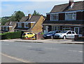
Rowan Way houses, Malpas, Newport
On the east side of Rowan Way between Pillmawr Road and Laurel Crescent.
Image: © Jaggery
Taken: 6 Jul 2017
0.02 miles
10
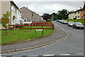
Pillmawr Circle, Malpas, Newport
Looking towards the blocked off end of the circle. The correct spelling is shown on this street sign. Here's the wrong spelling http://www.geograph.org.uk/photo/1442960
Image: © Jaggery
Taken: 15 Aug 2009
0.02 miles