IMAGES TAKEN NEAR TO
Robertson Way, NEWPORT, NP20 6QP
Introduction
This page details the photographs taken nearby to Robertson Way, NP20 6QP by members of the Geograph project.
The Geograph project started in 2005 with the aim of publishing, organising and preserving representative images for every square kilometre of Great Britain, Ireland and the Isle of Man.

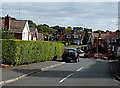
There are currently over 7.5m images from over14,400 individuals and you can help contribute to the project by visiting https://www.geograph.org.uk
Image Map
Images are licensed for reuse under creativecommons.org/licenses/by-sa/2.0
Notes
- Clicking on the map will re-center to the selected point.
- The higher the marker number, the further away the image location is from the centre of the postcode.
Image Listing (835 Images Found)
Images are licensed for reuse under creativecommons.org/licenses/by-sa/2.0
Image
Details
Distance
1
Robertson Way electricity substation, Malpas, Newport
The Western Power Distribution electricity substation is in a fenced compound
at the edge of a path from Robertson Way to Horrocks Close (ahead).
Image: © Jaggery
Taken: 7 Mar 2015
0.02 miles
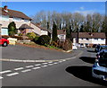
2
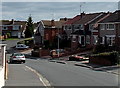
Robertson Way, Malpas, Newport
Viewed in late September 2014. Since the spring of 2014, Robertson Way has been part of a cold calling control zone. http://www.geograph.org.uk/photo/4181647
Image: © Jaggery
Taken: 26 Sep 2014
0.02 miles
3
Far end of Horrocks Close, Malpas, Newport
Viewed from the corner of Wavell Drive.
Image: © Jaggery
Taken: 8 Mar 2010
0.03 miles
4
Turning circle at the far end of Horrocks Close, Malpas, Newport
Horrocks Close connects with Wavell Drive.
Image: © Jaggery
Taken: 13 Feb 2012
0.03 miles
5
Western end of Robertson Way, Malpas, Newport
Looking past a long hedge from the corner of Wavell Drive.
Image: © Jaggery
Taken: 26 Sep 2014
0.03 miles
6
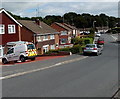
Kelly Communications van in Malpas, Newport
The white van is parked on the drive of a Robertson Way house. The Kelly website states that since 1985, the Kelly Group has become the UK's leading national telecommunications and utilities service provider, operating in industries as diverse as telecommunications, rail, metro, highways and brewery installation.
Image: © Jaggery
Taken: 26 Sep 2014
0.03 miles
7
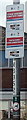
Cold calling control zone notice in Robertson Way, Malpas, Newport
From the spring of 2014, notices such as this one have been erected in the Woodlands area of Malpas. The intention is to discourage unwanted cold callers. Breaches of the zone can be reported to trading standards, who will contact offending businesses asking them to refrain from doing so again.
Image: © Jaggery
Taken: 26 Sep 2014
0.05 miles
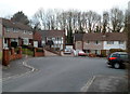
8

Robertson Way, Malpas
Viewed from Wavell Drive.
Image: © Jaggery
Taken: 19 Dec 2009
0.05 miles
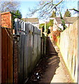
9
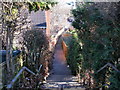
Shortcut from Horrocks Close to Robertson Way, Malpas, Newport
Steps lead down from Horrocks Close to a footpath between perimeter fences of house gardens.
Image: © Jaggery
Taken: 8 Mar 2010
0.05 miles
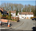
10
Corner of Horrocks Close and Alanbrooke Avenue, Malpas, Newport
Alanbrooke Avenue is on the left. The roads are named after Second World War field marshals and generals.
Lieutenant General Sir Brian Gwynne Horrocks KCB, KBE, DSO, MC (1895–1985) was the commander of XXX Corps in Operation Market Garden and other operations during the Second World War.
Field Marshal Alan Francis Brooke, 1st Viscount Alanbrooke KG, GCB, OM, GCVO, DSO & Bar (1883–1963) was the Chief of the Imperial General Staff during the Second World War. He was promoted to field marshal in 1944.
Image: © Jaggery
Taken: 7 Mar 2015
0.06 miles