IMAGES TAKEN NEAR TO
Alanbrooke Avenue, NEWPORT, NP20 6QH
Introduction
This page details the photographs taken nearby to Alanbrooke Avenue, NP20 6QH by members of the Geograph project.
The Geograph project started in 2005 with the aim of publishing, organising and preserving representative images for every square kilometre of Great Britain, Ireland and the Isle of Man.

There are currently over 7.5m images from over14,400 individuals and you can help contribute to the project by visiting https://www.geograph.org.uk
Image Map
Images are licensed for reuse under creativecommons.org/licenses/by-sa/2.0
Notes
- Clicking on the map will re-center to the selected point.
- The higher the marker number, the further away the image location is from the centre of the postcode.
Image Listing (322 Images Found)
Images are licensed for reuse under creativecommons.org/licenses/by-sa/2.0
Image
Details
Distance
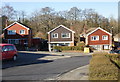
1
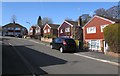
Houses on the north side of Alanbrooke Avenue, Malpas, Newport
Detached houses here, semi-detached houses in the background.
Image: © Jaggery
Taken: 7 Mar 2015
0.02 miles
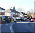
2
Junction of Alanbrooke Avenue and Wavell Drive, Malpas, Newport
Viewed from Montgomery Road. Left for Alanbrooke Avenue, right for Wavell Drive.
The roads in this area are named after Second World War field marshals and generals.
Image: © Jaggery
Taken: 7 Mar 2015
0.03 miles
3
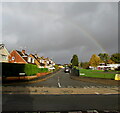
Faint rainbow over Malpas, Newport
Looking north from Almond Drive along Wavell Drive at 9am on November 1st 2020.
Image: © Jaggery
Taken: 1 Nov 2020
0.03 miles
4
Alanbrooke Avenue houses, Malpas, Newport
Houses on the west side of Alanbrooke Avenue, at the start of a sharp bend to the right.
Image: © Jaggery
Taken: 8 Mar 2010
0.04 miles
5
Houses on the north side of Alanbrooke Avenue, Malpas, Newport
This is the far end of Alanbrooke Avenue, which is roughly horseshoe-shaped.
Beyond the right edge of the photo, the avenue continues to Horrocks Close.
Image: © Jaggery
Taken: 8 Mar 2010
0.04 miles
6
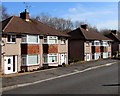
Alanbrooke Avenue houses, Malpas, Newport
Semi-detached houses set slightly below road level.
Image: © Jaggery
Taken: 7 Mar 2015
0.05 miles
7
South side of Montgomery Road, Malpas, Newport
Viewed from the Malpas Road (A4051) end looking towards the right turn for Arlington Close. The roads in this area are named after Second World War field marshals and generals. The houses were built in the late 1950s.
Image: © Jaggery
Taken: 28 Feb 2015
0.06 miles
8
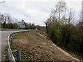
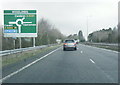
Bank below the A4042 near Woodlands Roundabout, Cwmbran
In March 2020 a few tree stumps are near the barrier. A May 2018
Google Street View shows trees extending as far as the metal barrier.
Image: © Jaggery
Taken: 28 Mar 2020
0.06 miles
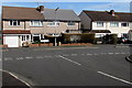
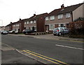
10
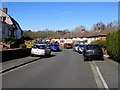
Cars parked on Alanbrooke Avenue pavements, Malpas, Newport
Walkers have to use to the roadway to pass cars parked on pavements. All the houses have garages,
so perhaps these are visitors' cars, or maybe the garages contain freezers, washing machines etc.
Image: © Jaggery
Taken: 7 Mar 2015
0.06 miles