IMAGES TAKEN NEAR TO
Malpas Road, NEWPORT, NP20 6QA
Introduction
This page details the photographs taken nearby to Malpas Road, NP20 6QA by members of the Geograph project.
The Geograph project started in 2005 with the aim of publishing, organising and preserving representative images for every square kilometre of Great Britain, Ireland and the Isle of Man.

There are currently over 7.5m images from over14,400 individuals and you can help contribute to the project by visiting https://www.geograph.org.uk
Image Map
Images are licensed for reuse under creativecommons.org/licenses/by-sa/2.0
Notes
- Clicking on the map will re-center to the selected point.
- The higher the marker number, the further away the image location is from the centre of the postcode.
Image Listing (818 Images Found)
Images are licensed for reuse under creativecommons.org/licenses/by-sa/2.0
Image
Details
Distance
1
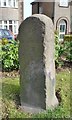
Old Milestone by the A4051, Malpas Road, Llantarnam
By the A4051, in parish of Llantarman (Torfaen County Borough District), Malpas Road, Llantarnam, 400m South of roundabout by No 574, East side of road.
Inscription reads:- : TO / NEWPORT / 2¼ / MILES : : TO / PONTYPOOL / 7 / MILES :
To be surveyed
Milestone Society National ID: MON_NPPP02
Image: © Milestone Society
Taken: Unknown
0.01 miles
2
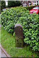
South side of an old milestone, Malpas, Newport
Located on the east side of the A4051 Malpas Road, midway between the Woodlands
Drive junction to the south and the Montgomery Road junction to the north.
The faded inscription shows TO PONTYPOOL. The distance is no longer legible.
Image: © Jaggery
Taken: 8 Jan 2016
0.01 miles
3
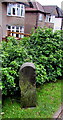
North side of an old milestone, Malpas, Newport
Located on the east side of the A4051 Malpas Road, midway between the Woodlands
Drive junction to the south and the Montgomery Road junction to the north.
The faded inscription shows TO NEWPORT. The distance is no longer legible.
Image: © Jaggery
Taken: 8 Jan 2016
0.01 miles
4
Arlington Close, Malpas, Newport
Viewed from Montgomery Road.
Image: © Jaggery
Taken: 17 Oct 2009
0.02 miles
5
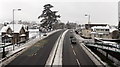
A wintry view north from a Malpas Road footbridge, Newport
The road surface has been cleared, but pavements remain hazardous to walk on, with a mixture of snow and icy compacted snow. The house on the left is North Lodge, near the corner of Whittle Drive.
Image: © Jaggery
Taken: 20 Jan 2013
0.02 miles
6
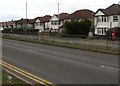
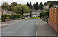
Detached houses on the east side of Malpas Road, Newport
Houses between Woodlands Drive and Montgomery Road in the north of Newport near the Torfaen boundary.
Image: © Jaggery
Taken: 3 Feb 2018
0.03 miles
7
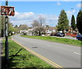
Big Pit direction sign, Malpas Road, Newport
Facing the A4051 Malpas Road in the north of Newport, near the Newport/Torfaen boundary (ahead).
No words are on the sign, presumably on the basis that if you're on your way to the Big Pit National Coal Museum in Blaenavon (about 20km to the north), you'll understand the symbol.
Image: © Jaggery
Taken: 16 Apr 2016
0.03 miles
8
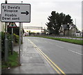
Turn right ahead for St David's Hospice, Malpas, Newport
The sign alongside the A4051 Malpas Road points to the right turn into Whittle Drive,
a few metres beyond the footbridge. North Lodge http://www.geograph.org.uk/photo/1626052 is on the right.
Image: © Jaggery
Taken: 8 Jan 2016
0.03 miles
9

Detached houses, Malpas Road, Newport
On the east side of the A4051 Malpas Road, between Montgomery Road and Woodlands Drive.
The sign http://www.geograph.org.uk/photo/4788424 on the lamppost shows turn right for St David's Hospice.
Image: © Jaggery
Taken: 16 Apr 2016
0.03 miles
10
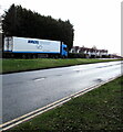
Nagel-Group lorry, Malpas, Newport
Six-axle articulated lorry travelling south on the A4051 Malpas Road in March 2021.
Image: © Jaggery
Taken: 11 Mar 2021
0.03 miles