IMAGES TAKEN NEAR TO
Bacon Place, NEWPORT, NP20 6NR
Introduction
This page details the photographs taken nearby to Bacon Place, NP20 6NR by members of the Geograph project.
The Geograph project started in 2005 with the aim of publishing, organising and preserving representative images for every square kilometre of Great Britain, Ireland and the Isle of Man.

There are currently over 7.5m images from over14,400 individuals and you can help contribute to the project by visiting https://www.geograph.org.uk
Image Map
Images are licensed for reuse under creativecommons.org/licenses/by-sa/2.0
Notes
- Clicking on the map will re-center to the selected point.
- The higher the marker number, the further away the image location is from the centre of the postcode.
Image Listing (1988 Images Found)
Images are licensed for reuse under creativecommons.org/licenses/by-sa/2.0
Image
Details
Distance
1

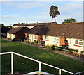
Block of three-storey flats, Bacon Place, Newport
Viewed from the corner of Edison Ridge in May 2020.
Image: © Jaggery
Taken: 17 May 2020
0.01 miles
2
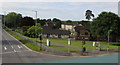
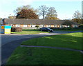
Bungalows below Malpas Road, Newport
Located between Malpas Road and Bacon Place. Originally, bungalow was used in English for a lightly-built house, with a veranda and one storey. In current UK usage it is a convenient word for any one-storey dwelling.
Image: © Jaggery
Taken: 22 May 2019
0.02 miles
3
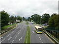
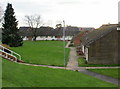
View from a Malpas Road footbridge, Newport
Looking towards housing in Bacon Place. The white arrows are on the A4051 Malpas Road.
Image: © Jaggery
Taken: 17 May 2020
0.03 miles
4
Malpas Road, Newport
Looking north from the footbridge opposite Russell Drive
Image: © Jaggery
Taken: 12 Aug 2009
0.03 miles
5
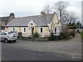
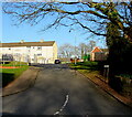
South Lodge, Malpas Road, Newport
Formerly the south lodge of the Malpas Court http://www.geograph.org.uk/photo/1431680 estate, now a private residence on the corner of Malpas Road and Llewellyn Grove.
http://www.geograph.org.uk/photo/1626052 to the former north lodge.
Image: © Jaggery
Taken: 19 Dec 2009
0.03 miles
6
Bungalows, Malpas Road, Newport
Set back from the west side of Malpas Road, near the corner of Whittle Drive.
Image: © Jaggery
Taken: 19 Dec 2009
0.03 miles
7
Malpas Road bungalows viewed from Bacon Place, Newport
Bungalows http://www.geograph.org.uk/photo/1625344 on the west side of Malpas Road abut the eastern edge of Bacon Place.
Image: © Jaggery
Taken: 30 Oct 2010
0.03 miles
8
Up Bacon Place, Malpas, Newport
Bacon Place ascends to the NE away from the road named Edison Ridge.
Image: © Jaggery
Taken: 12 Feb 2021
0.03 miles
9
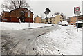
Icy road surface, Bacon Place, Malpas, Newport
The 20mph speed limit in force along Whittle Drive (near Malpas Court Primary School) increases to 30mph along Bacon Place. There were few cars being driven hereabouts on this wintry Sunday morning in January.
Image: © Jaggery
Taken: 20 Jan 2013
0.03 miles
10
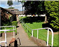
Path to bungalows below Malpas Road, Newport
A nearby sign shows 571 - 601 Malpas Road.
Image: © Jaggery
Taken: 2 Jul 2019
0.03 miles