IMAGES TAKEN NEAR TO
Edison Ridge, NEWPORT, NP20 6NQ
Introduction
This page details the photographs taken nearby to Edison Ridge, NP20 6NQ by members of the Geograph project.
The Geograph project started in 2005 with the aim of publishing, organising and preserving representative images for every square kilometre of Great Britain, Ireland and the Isle of Man.

There are currently over 7.5m images from over14,400 individuals and you can help contribute to the project by visiting https://www.geograph.org.uk
Image Map
Images are licensed for reuse under creativecommons.org/licenses/by-sa/2.0
Notes
- Clicking on the map will re-center to the selected point.
- The higher the marker number, the further away the image location is from the centre of the postcode.
Image Listing (1827 Images Found)
Images are licensed for reuse under creativecommons.org/licenses/by-sa/2.0
Image
Details
Distance
1
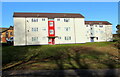
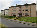
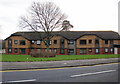
Edison Ridge flats, Malpas, Newport
Newport City Homes flats viewed across the road named Edison Ridge in February 2021.
Image: © Jaggery
Taken: 12 Feb 2021
0.00 miles
2
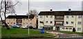
Bacon Place flats, Malpas, Newport
Newport City Homes flats viewed from Whittle Drive.
Image: © Jaggery
Taken: 3 Feb 2018
0.01 miles
3
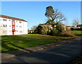
Flats and trees, Edison Ridge, Malpas, Newport
The trees are alongside a small, unnamed stream.
Image: © Jaggery
Taken: 16 Aug 2014
0.01 miles
4
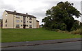
Three-storey flats set back from Edison Ridge, Malpas, Newport
Located between Edison Ridge and Bacon Place.
Image: © Jaggery
Taken: 17 May 2020
0.01 miles
5
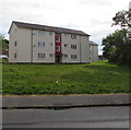
Three-storey flats, Edison Ridge, Newport
In the Malpas area of Newport.
Image: © Jaggery
Taken: 17 May 2020
0.01 miles
6
Trees and flats, Edison Ridge, Malpas, Newport
Viewed across the road named Edison Ridge in February 2021.
Image: © Jaggery
Taken: 12 Feb 2021
0.02 miles
7
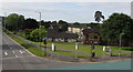
View from a Malpas Road footbridge, Newport
Looking towards housing in Bacon Place. The white arrows are on the A4051 Malpas Road.
Image: © Jaggery
Taken: 17 May 2020
0.02 miles
8
SE along Edison Ridge, Malpas, Newport
Looking to the southeast along Edison Ridge towards Hargreaves Drive and Bacon Place.
Image: © Jaggery
Taken: 17 May 2020
0.02 miles
9
Whittle Court, Malpas, Newport
Sheltered housing on the south side of Whittle Drive. Sheltered housing is accommodation which is purpose built for persons:
• Over 60 years of age who are able to maintain a high level of independent living and who do not display signs of dementia or confusion.
• Below 60 years of age who have a physical disability and are registered disabled, provided they can maintain a high degree of independent living.
Each sheltered scheme has a manager who acts as a “good neighbour” and maintains regular contact with residents. There are also direct links to the Resident Service Centre (Emergency Control Centre) when the scheme manager is not on duty. The manager or the Resident Service Centre will assist residents in the event of an emergency.
Image: © Jaggery
Taken: 19 Dec 2009
0.03 miles
10
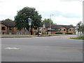
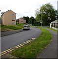
Corner of Whittle Drive and Malpas Road, Newport
Viewed across Malpas Road. The speed limit reduces from 40mph along Malpas Road to 20mph in Whittle Drive. A school http://www.geograph.org.uk/photo/1433078 is nearby.
Image: © Jaggery
Taken: 7 Aug 2010
0.03 miles