IMAGES TAKEN NEAR TO
Malpas Road, NEWPORT, NP20 6NF
Introduction
This page details the photographs taken nearby to Malpas Road, NP20 6NF by members of the Geograph project.
The Geograph project started in 2005 with the aim of publishing, organising and preserving representative images for every square kilometre of Great Britain, Ireland and the Isle of Man.

There are currently over 7.5m images from over14,400 individuals and you can help contribute to the project by visiting https://www.geograph.org.uk
Image Map
Images are licensed for reuse under creativecommons.org/licenses/by-sa/2.0
Notes
- Clicking on the map will re-center to the selected point.
- The higher the marker number, the further away the image location is from the centre of the postcode.
Image Listing (2099 Images Found)
Images are licensed for reuse under creativecommons.org/licenses/by-sa/2.0
Image
Details
Distance
1
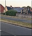
Northeast side of North Lodge, Malpas, Newport
Viewed across the A4051 Malpas Road in July 2022. Now a private residence, formerly the north lodge of Malpas Court.
Image: © Jaggery
Taken: 16 Jul 2022
0.00 miles
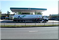
2
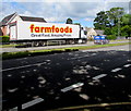
Farmfoods lorry, Malpas Road, Newport
Great Food, Amazing Prices is on the side of the articulated lorry.
Farmfoods is a frozen food business based in Cumbernauld, Scotland.
The company has more than 300 stores in the UK.
Image: © Jaggery
Taken: 2 Jul 2019
0.00 miles
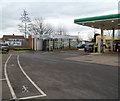
3
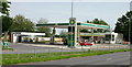
Simply Food Connect, Malpas, Newport
On the A4051 , east side of Malpas Road just before the junction with Almond Drive. Opened November 2008. The site is a joint M&S and BP venture and contains M&S Simply Food, BP Connect and Wild Bean Cafe. There is also a Hydrocar carwash. Note for future historians - prices shown (Aug 8 2009) are regular unleaded £1.019 per litre, regular diesel £1.029 per litre.
Image: © Jaggery
Taken: 8 Aug 2009
0.01 miles
4
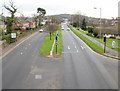
Malpas Road south from Woodlands footbridge, Newport
Looking south along Malpas Road from the footbridge located between Whittle Drive and Woodlands Drive.
Image: © Jaggery
Taken: 19 Dec 2009
0.01 miles
5
Fuelling the future, Malpas Road, Newport
A BP fuel tanker, bearing BP's London 2012 logo, is parked at the Simply Food Connect and BP Connect site http://www.geograph.org.uk/photo/1433528 on Malpas Road.
Image: © Jaggery
Taken: 20 Jun 2011
0.01 miles
6
HydroCare, Malpas Road, Newport
The No Entry sign is at the exit from the HydroCare car wash located in the Simply Food Connect www.geograph.org.uk/photo/1433528 site on Malpas Road.
Image: © Jaggery
Taken: 13 Feb 2012
0.01 miles
7
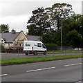
Randalls van, Malpas Road, Newport
Randalls (Groundworks) Ltd is based in Monmouth House, Park Road, Abergavenny. https://www.geograph.org.uk/photo/6378525
Image: © Jaggery
Taken: 16 Aug 2019
0.01 miles
8
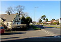
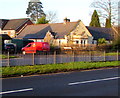
Junction of Llewellyn Grove and Malpas Road, Newport
From the left, Llewellyn Grove joins the northbound carriageway of the A4051 Malpas Road.
Image: © Jaggery
Taken: 12 Feb 2021
0.01 miles
9
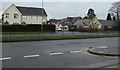
Old and new, Malpas, Newport
Viewed across the A4051 Malpas Road looking towards the Llewellyn Grove junction.
South Lodge on the right is many decades older than the early 21st century houses nearby.
Image: © Jaggery
Taken: 22 Nov 2019
0.01 miles
10
Royal Mail van, Llewellyn Grove, Malpas, Newport
The red van is parked while its driver delivers letters and small parcels to nearby houses on December 30th 2019.
Image: © Jaggery
Taken: 30 Dec 2019
0.01 miles