IMAGES TAKEN NEAR TO
Pilton Vale, NEWPORT, NP20 6LT
Introduction
This page details the photographs taken nearby to Pilton Vale, NP20 6LT by members of the Geograph project.
The Geograph project started in 2005 with the aim of publishing, organising and preserving representative images for every square kilometre of Great Britain, Ireland and the Isle of Man.

There are currently over 7.5m images from over14,400 individuals and you can help contribute to the project by visiting https://www.geograph.org.uk
Image Map
Images are licensed for reuse under creativecommons.org/licenses/by-sa/2.0
Notes
- Clicking on the map will re-center to the selected point.
- The higher the marker number, the further away the image location is from the centre of the postcode.
Image Listing (1243 Images Found)
Images are licensed for reuse under creativecommons.org/licenses/by-sa/2.0
Image
Details
Distance
1
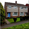
292 Pilton Vale Newport viewed on 29/2/2016
292 Pilton Vale is the house with the blue door, viewed on 29/2/2016.
February 29 (leap day) is a date that usually occurs once every four years. This day is added to the calendar in leap years as a corrective measure, because the Earth does not orbit the sun in exactly 365 days. Three leap days are omitted every 400 years. Thus 2000 and 2400 are leap years, but not 1800, 1900, 2100, 2200, 2300.
Image: © Jaggery
Taken: 29 Feb 2016
0.01 miles
2
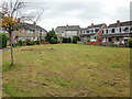
Pilton Vale, Newport
Houses in this part of Pilton Vale are arranged along the edge of a grassed quadrilateral area.
Image: © Jaggery
Taken: 28 Sep 2009
0.02 miles
3
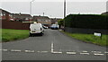
288-323 Pilton Vale, Malpas, Newport
Part of a housing estate of 385 dwellings, built in the mid to late 1960s, in Malpas in the north of Newport. There are no individual street names - the address of each house is a number and Pilton Vale, such as 288 Pilton Vale. It is easy for someone unfamiliar with the area (such as this contributor) to be unsure of exactly where they are in Pilton Vale, though there are many signs showing the way to various groups of house numbers.
Image: © Jaggery
Taken: 21 Feb 2015
0.03 miles
4
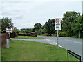
275-299 Pilton Vale, Malpas, Newport
House numbers in Pilton Vale range from 1 to 387. The sign on the right shows that numbers 275-299 are ahead.
Image: © Jaggery
Taken: 15 Jul 2017
0.03 miles
5
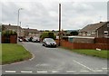
275-299 Pilton Vale, Newport
A dead-end part of the Pilton Vale housing estate in the Malpas area of Newport.
Image: © Jaggery
Taken: 18 Oct 2020
0.03 miles
6
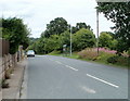
SE edge of Pilton Vale, Newport
Pilton Vale is a late 1960s housing development in Malpas. This is a view of the road around the eastern and southeastern edge of Pilton Vale. It is part of Newport Bus route 18.
Image: © Jaggery
Taken: 25 Jul 2010
0.04 miles
7
Trees on the eastern edge of Pilton Vale, Newport
Trees line the eastern side of a road around the edge of Pilton Vale. Beyond the trees is a nature walk in an area adjacent to the A4042.
The bus shelter is alongside a stop on Newport Bus route 18.
Image: © Jaggery
Taken: 25 Jul 2010
0.04 miles
8
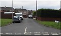
An arm of Pilton Vale, Newport
This is one of many arms that branch off from the main routes through Pilton Vale.
This one contains houses 275-299 Pilton Vale.
Image: © Jaggery
Taken: 25 Jul 2010
0.04 miles
9
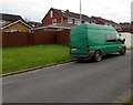
Green van in Pilton Vale, Malpas, Newport
"The leader for tree solutions" is on the back and side of the van. RAIL is on the van door.
Image: © Jaggery
Taken: 26 Feb 2016
0.04 miles
10

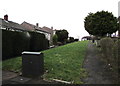
Snowy grass triangle, Pilton Vale, Malpas, Newport
The trees are on a grass triangle between two paths alongside Pilton Vale houses.
Image: © Jaggery
Taken: 20 Jan 2013
0.05 miles