IMAGES TAKEN NEAR TO
Pilton Vale, NEWPORT, NP20 6LH
Introduction
This page details the photographs taken nearby to Pilton Vale, NP20 6LH by members of the Geograph project.
The Geograph project started in 2005 with the aim of publishing, organising and preserving representative images for every square kilometre of Great Britain, Ireland and the Isle of Man.

There are currently over 7.5m images from over14,400 individuals and you can help contribute to the project by visiting https://www.geograph.org.uk
Image Map
Images are licensed for reuse under creativecommons.org/licenses/by-sa/2.0
Notes
- Clicking on the map will re-center to the selected point.
- The higher the marker number, the further away the image location is from the centre of the postcode.
Image Listing (876 Images Found)
Images are licensed for reuse under creativecommons.org/licenses/by-sa/2.0
Image
Details
Distance
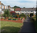
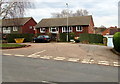
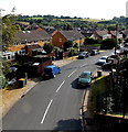
1

Sharp end of a grass triangle in Pilton Vale, Newport
Pilton Vale is a housing estate of 385 dwellings, built in the mid to late 1960s, in Malpas in the north of Newport. There are no individual street names - the address of each house is a number and Pilton Vale, such as 123 Pilton Vale. It is easy for someone unfamiliar with the area (such as this contributor) to be unsure of exactly where they are in Pilton Vale, though there are many signs showing the way to various groups of house numbers. I thought the way ahead was a through route. I was wrong!
Image: © Jaggery
Taken: 26 Jul 2014
0.01 miles
2
Pilton Vale houses in Newport
Some of the paths through the Pilton Vale housing estate are through routes.
This one isn't, ending at the row of houses.
Image: © Jaggery
Taken: 26 Jul 2014
0.02 miles
3
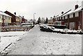
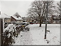
A snowy arm of Pilton Vale, Malpas, Newport
Viewed during a cold spell in January 2013. Built in the mid to late 1960s, the houses in Pilton Vale are designed so that as far as possible, pedestrians and motor vehicles are segregated. There is a network of footpaths through the estate.
Image: © Jaggery
Taken: 20 Jan 2013
0.02 miles
4
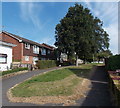
Pilton Vale, Malpas, Newport
Built in the mid to late 1960s, Pilton Vale was designed to keep pedestrians and motor vehicles apart as far as possible. Here, footpaths give access to the fronts of houses. Out of shot, interconnected roads lead to the backs of houses.
Image: © Jaggery
Taken: 26 Jul 2014
0.04 miles
5
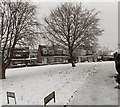
A white green, Pilton Vale, Malpas, Newport
This triangular green in Pilton Vale was white for about a week during a cold spell in January 2013.
The occurrence of lying snow is very variable in this part of low-lying SE Wales. In a few years, there is little or no lying snow. At the other extreme, in a few years, snow covers the ground for many days or even weeks. Two particularly snowy years in the 20th century, (here and in many other locations in the UK) were 1963 and 1947.
Image: © Jaggery
Taken: 20 Jan 2013
0.04 miles
6
Snowy NW corner of Pilton Vale, Malpas, Newport
Viewed during a cold spell in January 2013. This part of the Pilton Vale housing estate is near the southern edge of the Claremont housing estate, both built in the 1960s.
Image: © Jaggery
Taken: 20 Jan 2013
0.04 miles
7
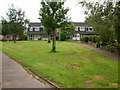
Northern edge of Pilton Vale
The Claremont and Pilton Vale private housing estates are coterminous. This triangle of grass is at the southern edge of Claremont. Beyond are houses on the northern edge of Pilton Vale.
Image: © Jaggery
Taken: 15 Aug 2009
0.05 miles
8
159-180 Pilton Vale, Newport
22 of the nearly 400 houses in Pilton Vale.
Image: © Jaggery
Taken: 18 Oct 2020
0.05 miles
9
Pilton Vale houses, Malpas, Newport
A small part of a large housing estate on the east side of Rowan Way, built in the 1960s.
Image: © Jaggery
Taken: 26 Feb 2016
0.06 miles
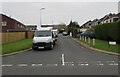
10
Pilton Vale road and houses, Newport
Viewed from this http://www.geograph.org.uk/photo/2534978 footbridge.
Image: © Jaggery
Taken: 26 Jul 2014
0.06 miles