IMAGES TAKEN NEAR TO
Graig Wood Close, NEWPORT, NP20 6HH
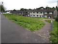
Introduction
This page details the photographs taken nearby to Graig Wood Close, NP20 6HH by members of the Geograph project.
The Geograph project started in 2005 with the aim of publishing, organising and preserving representative images for every square kilometre of Great Britain, Ireland and the Isle of Man.

There are currently over 7.5m images from over14,400 individuals and you can help contribute to the project by visiting https://www.geograph.org.uk
Image Map
Images are licensed for reuse under creativecommons.org/licenses/by-sa/2.0
Notes
- Clicking on the map will re-center to the selected point.
- The higher the marker number, the further away the image location is from the centre of the postcode.
Image Listing (827 Images Found)
Images are licensed for reuse under creativecommons.org/licenses/by-sa/2.0
Image
Details
Distance
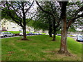
1
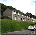
Houses on a bank above Graig Wood Close, Newport
Behind the houses is Graig Wood on a slope ascending to the Brynglas area of Newport.
Image: © Jaggery
Taken: 23 May 2020
0.00 miles
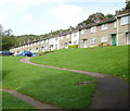
2
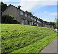
Row of houses on a bank above Graig Wood Close, Malpas, Newport
The row extends for 45 metres. Houses on the opposite side of Graig Wood Close are set below road level. http://www.geograph.org.uk/photo/5122465
Image: © Jaggery
Taken: 6 Jul 2016
0.00 miles
3
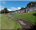
Path to the southern edge of Graig Wood Close, Newport
The northern end of this http://www.geograph.org.uk/photo/4101081 path from Malpas Road.
Image: © Jaggery
Taken: 2 Aug 2014
0.01 miles
4
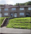
Steps up to Graig Wood Close houses, Newport
The tops of trees in Graig Wood are in the background.
Image: © Jaggery
Taken: 6 Jul 2016
0.02 miles
5
Among the trees, Graig Wood Close, Newport
Located here. https://www.geograph.org.uk/photo/6485076
Image: © Jaggery
Taken: 23 May 2020
0.02 miles
6
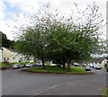
Trees at the southern end of Graig Wood Close, Newport
In the middle on the turning area at the southern end of the dead-end road.
Image: © Jaggery
Taken: 23 May 2020
0.02 miles
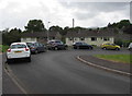
7
Graig Wood Close houses, Newport
Houses on the east side of Graig Wood Close, viewed from just beyond the loop http://www.geograph.org.uk/photo/1940325 at the end of the close
Image: © Jaggery
Taken: 1 Sep 2009
0.02 miles
8
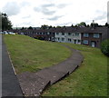
Path down to houses on the west side of Graig Wood Close, Newport
Graig Wood Close is built on a slope of Brynglas. Houses on this side are below road level.
Those on the east side are above road level. http://www.geograph.org.uk/photo/4101154
Image: © Jaggery
Taken: 2 Aug 2014
0.03 miles
9
Path to houses below Graig Wood Close, Newport
Houses on this side of Graig Wood Close are set below road level
Image: © Jaggery
Taken: 23 May 2020
0.03 miles
10
Graig Wood Close turning area, Newport
About 250 metres from the other end of Graig Wood Close at the Graig Park Road junction.
Image: © Jaggery
Taken: 23 May 2020
0.03 miles