IMAGES TAKEN NEAR TO
Marconi Close, NEWPORT, NP20 6FX
Introduction
This page details the photographs taken nearby to Marconi Close, NP20 6FX by members of the Geograph project.
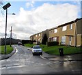
The Geograph project started in 2005 with the aim of publishing, organising and preserving representative images for every square kilometre of Great Britain, Ireland and the Isle of Man.

There are currently over 7.5m images from over14,400 individuals and you can help contribute to the project by visiting https://www.geograph.org.uk
Image Map
Images are licensed for reuse under creativecommons.org/licenses/by-sa/2.0
Notes
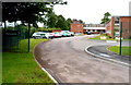
- Clicking on the map will re-center to the selected point.
- The higher the marker number, the further away the image location is from the centre of the postcode.
Image Listing (297 Images Found)
Images are licensed for reuse under creativecommons.org/licenses/by-sa/2.0
Image
Details
Distance
1
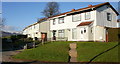
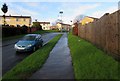
Marconi Close, Newport
Steel-framed houses on Marconi Close, viewed from the corner of Newton Way.
Marconi Close is one of three short streets connecting with Newton Way. Its two southern neighbours are Rankine Close http://www.geograph.org.uk/photo/1684699
and Boyle Close. http://www.geograph.org.uk/photo/1647657
Image: © Jaggery
Taken: 2 Jan 2010
0.02 miles
2
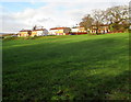
Parklands, Blackett Avenue, Malpas
Viewed from the path connecting Baird Close and Blackett Avenue.
Parklands is owned by Newport City Council. A care home for the elderly, it has 33 single rooms.
http://www.geograph.org.uk/photo/1685020 to a front view.
Image: © Jaggery
Taken: 30 Jan 2010
0.05 miles
3
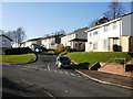
Darwin Drive, Newport
Steel-framed houses on the west side of Darwin Drive, viewed from the corner of Newton Way.
Image: © Jaggery
Taken: 2 Jan 2010
0.05 miles
4
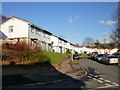
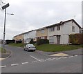
Kelvin Close, Newport
Steel-framed houses on the north side of Kelvin Close, viewed from Darwin Drive.
Image: © Jaggery
Taken: 2 Jan 2010
0.05 miles
5
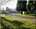
Darwin Drive pavement and wooden fence, Malpas, Newport
Darwin Drive ascends from the Faraday Close junction. http://www.geograph.org.uk/photo/4790502
Image: © Jaggery
Taken: 5 Jan 2016
0.06 miles
6
South side of Faraday Close, Malpas, Newport
Viewed from this path. http://www.geograph.org.uk/photo/4790524
Image: © Jaggery
Taken: 5 Jan 2016
0.06 miles
7
Partial renovation of Faraday Close, Malpas, Newport
This late February 2013 view shows that some houses (the ones with differently coloured upper and lower storeys) have been renovated and reroofed whereas others have not (yet?). http://www.geograph.org.uk/photo/1647594 to a view taken 3 years earlier.
Similar contrasts can be seen throughout this area, such as in Harvey Close. http://www.geograph.org.uk/photo/3342348
Image: © Jaggery
Taken: 22 Feb 2013
0.06 miles
8
Entrance to Parklands, Malpas, Newport
Viewed from Blackett Avenue.
Parklands is owned by Newport City Council. A care home for the elderly, it has 33 single rooms.
http://www.geograph.org.uk/photo/1685012 to a side view.
Image: © Jaggery
Taken: 30 Jan 2010
0.07 miles
9
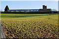
Parklands, Malpas, Newport
Located at a bend in Blackett Avenue. Parklands is a Newport City Council residential care home for 32 residents.
Image: © Jaggery
Taken: 15 Jun 2012
0.07 miles
10
Faraday Close, Malpas, Newport
Viewed across Darwin Drive. Out of shot, the far end of Faraday Close
is 80 metres from the disused Monmouthshire and Brecon canal.
Image: © Jaggery
Taken: 5 Jan 2016
0.07 miles