IMAGES TAKEN NEAR TO
Hollybush Avenue, NEWPORT, NP20 6ET
Introduction
This page details the photographs taken nearby to Hollybush Avenue, NP20 6ET by members of the Geograph project.
The Geograph project started in 2005 with the aim of publishing, organising and preserving representative images for every square kilometre of Great Britain, Ireland and the Isle of Man.

There are currently over 7.5m images from over14,400 individuals and you can help contribute to the project by visiting https://www.geograph.org.uk
Image Map
Images are licensed for reuse under creativecommons.org/licenses/by-sa/2.0
Notes
- Clicking on the map will re-center to the selected point.
- The higher the marker number, the further away the image location is from the centre of the postcode.
Image Listing (1615 Images Found)
Images are licensed for reuse under creativecommons.org/licenses/by-sa/2.0
Image
Details
Distance
1
A bend in Hollybush Avenue, Malpas, Newport
Looking towards Westfield Way and Hollybush Close from the edge of a footpath to Malpas Road.
Image: © Jaggery
Taken: 28 Feb 2012
0.03 miles
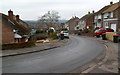
2
Looking north along Hollybush Avenue, Malpas, Newport
A view from near the Coolgreany Crescent turning. http://www.geograph.org.uk/photo/2824191
The crane in the distance is on the Westfield Rise building site. http://www.geograph.org.uk/photo/2797125
Image: © Jaggery
Taken: 28 Feb 2012
0.03 miles
3

Interlec Systems van in Westfield Way, Malpas, Newport
Domestic, commercial & industrial electrical installation contractors Interlec Systems are based in Constance Street Newport.
Image: © Jaggery
Taken: 6 Aug 2016
0.03 miles
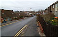
4

Southern end of Westfield Way, Malpas, Newport
Westfield Way from Westfield Drive ends at the Hollybush Avenue junction on the left.
Image: © Jaggery
Taken: 6 Apr 2020
0.03 miles
5
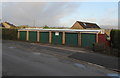
Six dark green doors, Westfield Way, Malpas, Newport
Row of six lockup garages near the Hollybush Avenue junction.
Door colour uniformity in April 2020 contrasts with this https://www.geograph.org.uk/photo/2221996 January 2011 view.
Image: © Jaggery
Taken: 6 Apr 2020
0.03 miles
6
Royal Mail drop box, Westfield Way, Malpas, Newport
The small box on the right is near recently-built houses.
Image: © Jaggery
Taken: 27 May 2017
0.03 miles
7
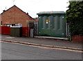
Hollybush Avenue electricity substation, Malpas, Newport
The identifier on the Western Power Distribution box is HOLLYBUSH NEWPORT S/S No. 532014.
Image: © Jaggery
Taken: 18 Jun 2014
0.04 miles
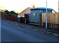
8
Hollybush Avenue electricity substation, Malpas, Newport
The identifier on the Western Power Distribution cabinet is HOLLYBUSH NEWPORT S/S No. 532014.
The cabinet is on the north side of Hollybush Avenue, behind a smaller telecoms cabinet.
Image: © Jaggery
Taken: 31 Oct 2016
0.04 miles
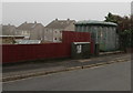
9
Three cabinets alongside Hollybush Avenue, Malpas, Newport
The large cabinet is a Western Power Distribution electricity substation.
Its identifier is HOLLYBUSH NEWPORT S/S 532014. A telecoms cabinet is on the left.
In between is a small relic of South Wales Electricity Board. https://www.geograph.org.uk/photo/6459992
Image: © Jaggery
Taken: 2 May 2020
0.04 miles
10
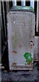
Reminder of the former South Wales Electricity Board, Hollybush Avenue, Newport
SOUTH WALES ELECTRICITY BOARD is embossed on the small cabinet located here. https://www.geograph.org.uk/photo/6459978 One of 12 Area Boards created under the terms of the Electricity Act 1947 which nationalised the more than 600 electric power companies in the UK, the South Wales Electricity Board was renamed SWALEC (South Wales Electricity) in 1990.
Image: © Jaggery
Taken: 2 May 2020
0.04 miles