IMAGES TAKEN NEAR TO
Allt-yr-Yn View, NEWPORT, NP20 5XE
Introduction
This page details the photographs taken nearby to Allt-yr-Yn View, NP20 5XE by members of the Geograph project.
The Geograph project started in 2005 with the aim of publishing, organising and preserving representative images for every square kilometre of Great Britain, Ireland and the Isle of Man.

There are currently over 7.5m images from over14,400 individuals and you can help contribute to the project by visiting https://www.geograph.org.uk
Image Map
Images are licensed for reuse under creativecommons.org/licenses/by-sa/2.0
Notes
- Clicking on the map will re-center to the selected point.
- The higher the marker number, the further away the image location is from the centre of the postcode.
Image Listing (176 Images Found)
Images are licensed for reuse under creativecommons.org/licenses/by-sa/2.0
Image
Details
Distance
1
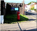
Pillarbox outside Raglan Barracks, Newport
Located here. http://www.geograph.org.uk/photo/5077890
Image: © Jaggery
Taken: 17 Aug 2016
0.01 miles
2
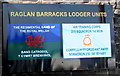
Raglan Barracks Lodger Units board, Newport
Located here. http://www.geograph.org.uk/photo/5077915 In August 2016, the lodger units are the Regimental Band of the Royal Welsh and Air Training Corps 210 Squadron 1st Mon.
Image: © Jaggery
Taken: 17 Aug 2016
0.02 miles
3
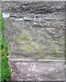
Ordnance Survey Cut Mark
This OS cut mark can be found on the wall of the Barracks. It marks a point 65.213m above mean sea level.
Image: © Adrian Dust
Taken: 17 Jun 2018
0.02 miles
4
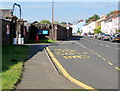
Raglan Barracks bus stop, Newport
In August 2016, the Allt-yr-yn View bus stop is on bus route N3, operated by NAT (New Adventure Travel).
SAFLE BWS on the road surface is Welsh for BUS STOP.
Image: © Jaggery
Taken: 17 Aug 2016
0.02 miles
5
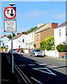
Give way to oncoming vehicles, Allt-yr-yn View, Newport
A vehicle should stop at the broken white lines if a vehicle is approaching.
The text is in English and Welsh.
Image: © Jaggery
Taken: 17 Aug 2016
0.03 miles
6
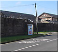
Advert on a BT phonebox, Allt-yr-yn View, Newport
On August 17th 2016, a McDonald's advert is on the side of the BT phonebox located near the Raglan Barracks perimeter wall.
Image: © Jaggery
Taken: 17 Aug 2016
0.03 miles
7
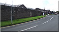
Raglan Barracks, Newport
Viewed across Allt-yr-yn View from the top of Barrack Hill. Construction of the barracks began in 1843. In 1845 work was complete on the first phase, designed to accommodate a cavalry regiment, although also used by some infantry units, and was variously known as Cavalry Barracks or Artillery Barracks. Renamed Raglan Barracks in 1963. Grade II listed in 1993.
Image: © Jaggery
Taken: 8 Sep 2016
0.03 miles
8
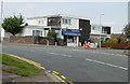
Allt-yr-yn Stores, Newport
Located at the top of Barrack Hill, on the corner of Allt-yr-yn View and Allt-yr-yn Way.
With typical Newport disregard for the phonetics of the Welsh original Allt-yr-ynn (the slope of the ash trees), the usual local pronunciation is 'alter-een'.
For some decades, the spelling Alteryn was sometimes used, but this variant is rarely seen now.
Image: © Jaggery
Taken: 18 Sep 2009
0.04 miles
9
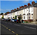
Row of houses, Allt-yr-yn View, Newport
Opposite Raglan Barracks (Territorial Army Centre) http://www.geograph.org.uk/photo/1954452
Image: © Jaggery
Taken: 17 Aug 2016
0.04 miles
10
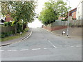
Bosworth Drive, Newport
Bosworth Drive heads away south from the top end of Barrack Hill.
Image: © Jaggery
Taken: 18 Sep 2009
0.05 miles