IMAGES TAKEN NEAR TO
Brynglas Road, NEWPORT, NP20 5RY
Introduction
This page details the photographs taken nearby to Brynglas Road, NP20 5RY by members of the Geograph project.
The Geograph project started in 2005 with the aim of publishing, organising and preserving representative images for every square kilometre of Great Britain, Ireland and the Isle of Man.

There are currently over 7.5m images from over14,400 individuals and you can help contribute to the project by visiting https://www.geograph.org.uk
Image Map
Images are licensed for reuse under creativecommons.org/licenses/by-sa/2.0
Notes
- Clicking on the map will re-center to the selected point.
- The higher the marker number, the further away the image location is from the centre of the postcode.
Image Listing (585 Images Found)
Images are licensed for reuse under creativecommons.org/licenses/by-sa/2.0
Image
Details
Distance
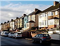
1
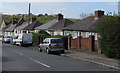
Houses below Brynglas Road, Newport
Two-storey houses set below road level on the west side of Brynglas Road.
Image: © Jaggery
Taken: 13 Apr 2020
0.02 miles
2
Bus stop sign on the Brynglas Road pavement, Newport
No buses on this route or elsewhere in the city today, Easter Monday April 13th 2020.
Image: © Jaggery
Taken: 13 Apr 2020
0.02 miles
3
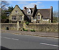
Stone house set back from the west side of Brynglas Road, Newport
This distinctive building is located 40 metres north of All Saints'
Community Church, so it may be the church rectory or former rectory.
Image: © Jaggery
Taken: 13 Apr 2020
0.04 miles
4
Brynglas Avenue houses, Newport
Houses on the west side of Brynglas Avenue, north of Brynglas Crescent. http://www.geograph.org.uk/photo/2046750
Image: © Jaggery
Taken: 2 Sep 2010
0.04 miles
5
Christmas morning sunshine in Brynglas Avenue, Newport
Viewed on Christmas Day 2013.
Image: © Jaggery
Taken: 25 Dec 2013
0.04 miles
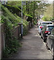
6
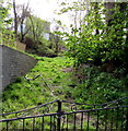
Track above Brynglas Road, Newport
Grassy track ascending from the east side of Brynglas Road.
Image: © Jaggery
Taken: 13 Apr 2020
0.05 miles
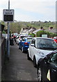
7

Row of houses on the west side of Brynglas Avenue, Newport
North of the Brynglas Crescent junction.
Image: © Jaggery
Taken: 15 Apr 2020
0.05 miles
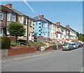
8

Brynglas Avenue semis, Newport
Semi-detached houses on the west side of Brynglas Avenue on the ascent towards Brynglas Road.
Image: © Jaggery
Taken: 15 Apr 2020
0.05 miles
9
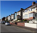
Houses on the west side of Brynglas Avenue, Newport
Semi-detached houses set above road level.
Houses on the opposite side of the road are set below road level. https://www.geograph.org.uk/photo/6449033
Image: © Jaggery
Taken: 15 Apr 2020
0.05 miles
10
Your speed indicator, Brynglas Road, Newport
Currently off, the display turns on to show the speed in green if an approaching vehicle is within the 30mph speed limit, or in red if over the speed limit.
Image: © Jaggery
Taken: 13 Apr 2020
0.05 miles