IMAGES TAKEN NEAR TO
Brynglas Court, NEWPORT, NP20 5QR
Introduction
This page details the photographs taken nearby to Brynglas Court, NP20 5QR by members of the Geograph project.
The Geograph project started in 2005 with the aim of publishing, organising and preserving representative images for every square kilometre of Great Britain, Ireland and the Isle of Man.

There are currently over 7.5m images from over14,400 individuals and you can help contribute to the project by visiting https://www.geograph.org.uk
Image Map
Images are licensed for reuse under creativecommons.org/licenses/by-sa/2.0
Notes
- Clicking on the map will re-center to the selected point.
- The higher the marker number, the further away the image location is from the centre of the postcode.
Image Listing (257 Images Found)
Images are licensed for reuse under creativecommons.org/licenses/by-sa/2.0
Image
Details
Distance
1
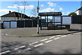
Bus stop and shelter on a Brynglas corner, Newport
On the corner of Brynglas Drive and Brynglas Court. Viewed in February 2016, when this stop is on New Adventure Travel Ltd route N2 from the city centre Market Square bus station via Malpas Road and Redland Street. Buses to the Brynglas area of Newport were formerly operated by Newport Bus, who abandoned this route as uneconomical.
Image: © Jaggery
Taken: 15 Feb 2016
0.03 miles
2
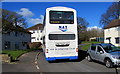
NAT double-decker, Brynglas Drive, Newport
Viewed in February 2016, when the bus is on NAT (New Adventure Travel Ltd) route N2 from the city centre Market Square bus station via Malpas Road and Redland Street. Buses to the Brynglas area of Newport were formerly operated by Newport Bus, who abandoned this route as uneconomical.
Image: © Jaggery
Taken: 15 Feb 2016
0.03 miles
3
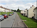
Brynglas Drive, Newport
The southeast part of Brynglas Drive, looking towards the junction with Brynglas Road.
Image: © Jaggery
Taken: 5 Aug 2009
0.03 miles
4
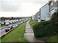
Brynglas Drive elevated pavements, Newport
Looking southwest along the elevated pavements on the southern section of Brynglas Drive.
Image: © Jaggery
Taken: 25 Oct 2009
0.03 miles
5
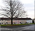
Tree at the junction of Brynglas Drive and Brynglas Court, Newport
The tree is probably decades older than the surrounding houses which were built c1950.
Brynglas Court is on the right.
Image: © Jaggery
Taken: 20 Dec 2013
0.04 miles
6
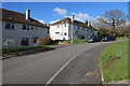
Brynglas Drive houses, Newport
At the western edge of the Brynglas area of Newport.
Image: © Jaggery
Taken: 15 Feb 2016
0.04 miles
7
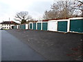
Long row of garages, Brynglas Drive, Newport
The row extends for about 40 metres.
Image: © Jaggery
Taken: 20 Dec 2013
0.06 miles
8
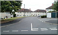
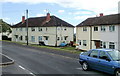
Brynglas Court, Newport
Viewed from Brynglas Drive. Brynglas Court is a long cul-de-sac ending at the edge of Graig Wood.
Image: © Jaggery
Taken: 18 Aug 2010
0.06 miles
9
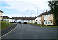
Change in house type, Brynglas Court, Newport
Houses on the left are larger and semi-detached. Those on the right are smaller and are part of a long row of houses. The view from the far end http://www.geograph.org.uk/photo/2019094 of the road shows the long row.
Image: © Jaggery
Taken: 18 Aug 2010
0.06 miles
10
Newport : Brynglas Court viewed from the far end
Viewed from the edge of Graig Wood.
Image: © Jaggery
Taken: 18 Aug 2010
0.06 miles