IMAGES TAKEN NEAR TO
Bryn Bevan, NEWPORT, NP20 5QJ
Introduction
This page details the photographs taken nearby to Bryn Bevan, NP20 5QJ by members of the Geograph project.
The Geograph project started in 2005 with the aim of publishing, organising and preserving representative images for every square kilometre of Great Britain, Ireland and the Isle of Man.

There are currently over 7.5m images from over14,400 individuals and you can help contribute to the project by visiting https://www.geograph.org.uk
Image Map
Images are licensed for reuse under creativecommons.org/licenses/by-sa/2.0
Notes
- Clicking on the map will re-center to the selected point.
- The higher the marker number, the further away the image location is from the centre of the postcode.
Image Listing (274 Images Found)
Images are licensed for reuse under creativecommons.org/licenses/by-sa/2.0
Image
Details
Distance
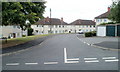
1

Footpath along the southern edge of Bryn Bevan, Newport
The footpath descends from the top of Bryn Bevan towards Brynglas Road.
Image: © Jaggery
Taken: 18 Aug 2010
0.04 miles
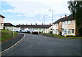
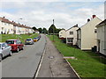
2
Brynglas Court, Newport
Viewed from Brynglas Drive. Brynglas Court is a long cul-de-sac ending at the edge of Graig Wood.
Image: © Jaggery
Taken: 18 Aug 2010
0.07 miles
3
Change in house type, Brynglas Court, Newport
Houses on the left are larger and semi-detached. Those on the right are smaller and are part of a long row of houses. The view from the far end http://www.geograph.org.uk/photo/2019094 of the road shows the long row.
Image: © Jaggery
Taken: 18 Aug 2010
0.07 miles
4
Newport : Brynglas Court viewed from the far end
Viewed from the edge of Graig Wood.
Image: © Jaggery
Taken: 18 Aug 2010
0.07 miles
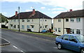
5

The far end of Bryn Bevan, Newport
The view SE from the edge of Graig Wood along Bryn Bevan, a residential road on the west side of Brynglas Road.
Image: © Jaggery
Taken: 18 Aug 2010
0.07 miles
6
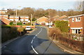
Bryn Bevan, Newport
Bryn Bevan is a 1970s development of about 150 houses, located between Brynglas Road (the only exit road from Bryn Bevan) and Graig Wood. This view was taken from a few metres north of Newport Lodge Hotel. http://www.geograph.org.uk/photo/1636044
Image: © Jaggery
Taken: 28 Dec 2009
0.07 miles
7

Bryn Bevan junction, Newport
Houses alongside the main route through Bryn Bevan, which runs from Brynglas Road to the edge of Graig Wood. The turning in the lower right corner is to houses on the eastern arm of Bryn Bevan.
Image: © Jaggery
Taken: 18 Aug 2010
0.08 miles
8
Brynglas Drive, Newport
The southeast part of Brynglas Drive, looking towards the junction with Brynglas Road.
Image: © Jaggery
Taken: 5 Aug 2009
0.08 miles
9
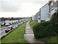
Brynglas Drive elevated pavements, Newport
Looking southwest along the elevated pavements on the southern section of Brynglas Drive.
Image: © Jaggery
Taken: 25 Oct 2009
0.08 miles
10
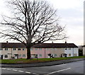
Tree at the junction of Brynglas Drive and Brynglas Court, Newport
The tree is probably decades older than the surrounding houses which were built c1950.
Brynglas Court is on the right.
Image: © Jaggery
Taken: 20 Dec 2013
0.08 miles