IMAGES TAKEN NEAR TO
Bryn Bevan, NEWPORT, NP20 5QH
Introduction
This page details the photographs taken nearby to Bryn Bevan, NP20 5QH by members of the Geograph project.
The Geograph project started in 2005 with the aim of publishing, organising and preserving representative images for every square kilometre of Great Britain, Ireland and the Isle of Man.

There are currently over 7.5m images from over14,400 individuals and you can help contribute to the project by visiting https://www.geograph.org.uk
Image Map
Images are licensed for reuse under creativecommons.org/licenses/by-sa/2.0
Notes
- Clicking on the map will re-center to the selected point.
- The higher the marker number, the further away the image location is from the centre of the postcode.
Image Listing (233 Images Found)
Images are licensed for reuse under creativecommons.org/licenses/by-sa/2.0
Image
Details
Distance
1
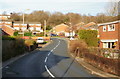
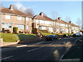
Bryn Bevan, Newport
Bryn Bevan is a 1970s development of about 150 houses, located between Brynglas Road (the only exit road from Bryn Bevan) and Graig Wood. This view was taken from a few metres north of Newport Lodge Hotel. http://www.geograph.org.uk/photo/1636044
Image: © Jaggery
Taken: 28 Dec 2009
0.05 miles
2

Footpath along the southern edge of Bryn Bevan, Newport
The footpath descends from the top of Bryn Bevan towards Brynglas Road.
Image: © Jaggery
Taken: 18 Aug 2010
0.06 miles
3
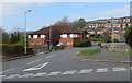
Fenced off former Newport Lodge Hotel, Brynglas, Newport
This late December 2013 across Bryn Bevan shows temporary fencing enclosing the former hotel.
A banner on the fence shows Cos Interiors office fit out & refurbishment contractors.
Image: © Jaggery
Taken: 28 Dec 2013
0.07 miles
4
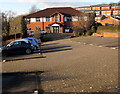
Into Bryn Bevan, Newport
From Brynglas Road into Bryn Bevan, an area of houses extending for 450 metres towards the edge of Graig Wood. Aria Care Home at 147 Bryn Bevan is on the left.
Image: © Jaggery
Taken: 13 Apr 2020
0.08 miles
5
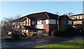
Aria Care Home, Brynglas, Newport
Viewed from Brynglas Road in late December 2014. Aria residential care home at
147 Bryn Bevan occupies a converted building which was previously Newport Lodge Hotel.
Image: © Jaggery
Taken: 30 Dec 2014
0.08 miles
6
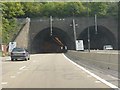
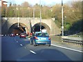
M4 Motorway - Brynglas tunnels, western portals
Image: © J Whatley
Taken: 22 Sep 2010
0.08 miles
7
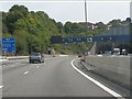
M4 Motorway approaching the Brynglas Tunnels
Lots of interest in this piece of road. The slip road from junction 26 comes in on the bend, with no margin for error in joining the reduced 2-lane carriageway, since the slip road ends at the tunnel abutment. It is very regrettable that the tunnels were only built with two lanes in each direction, particularly since the M4 junctions around Newport encourage local traffic to use this section. The sign on the left is worth a second look. Where a general geographic destination is shown, it is supposed to be indicative of the motorway's general direction. The M4 goes nowhere near The (English) Midlands! Even odder, the route is not a direct motorway connection: it's signed via the A449 and M50. All a bit of a muddle.
Image: © J Whatley
Taken: 22 Sep 2010
0.08 miles
8
The corner of Brynglas Avenue and Brynglas Road, Newport
Image: © Jaggery
Taken: 28 Dec 2009
0.09 miles
9
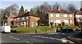
Top end of Brynglas Avenue, Newport
For most of its climb up Brynglas from Malpas Road via Redland Street, Brynglas Avenue follows a NE or NNE course. At the top of its climb, its course turns sharply to the west, to join Brynglas Road. These houses are on the north side of this top section, viewed from the corner of Brynglas Road.
Image: © Jaggery
Taken: 25 Nov 2010
0.09 miles
10
Newport : The M4 Motorway
Heading along the M4 Motorway before it heads through the Brynglas Tunnels.
Image: © Lewis Clarke
Taken: 23 Mar 2014
0.09 miles