IMAGES TAKEN NEAR TO
Jewell Lane, NEWPORT, NP20 5QD
Introduction
This page details the photographs taken nearby to Jewell Lane, NP20 5QD by members of the Geograph project.
The Geograph project started in 2005 with the aim of publishing, organising and preserving representative images for every square kilometre of Great Britain, Ireland and the Isle of Man.

There are currently over 7.5m images from over14,400 individuals and you can help contribute to the project by visiting https://www.geograph.org.uk
Image Map
Images are licensed for reuse under creativecommons.org/licenses/by-sa/2.0
Notes
- Clicking on the map will re-center to the selected point.
- The higher the marker number, the further away the image location is from the centre of the postcode.
Image Listing (798 Images Found)
Images are licensed for reuse under creativecommons.org/licenses/by-sa/2.0
Image
Details
Distance
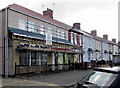
1
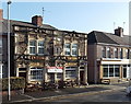
Lyceum Tavern, Crindau, Newport
Pub at 110 Malpas Road on the corner of Jewell Lane. The four picnic benches are a popular location
for customers to sit in warmer weather.
Kelly's Directory of Monmouthshire 1901 edition shows that 110 Malpas Road was a grocer's shop at the start of the 20th century. At that time, this was about as far as buildings reached along Malpas Road from the town centre.
Image: © Jaggery
Taken: 27 Jan 2013
0.02 miles
2
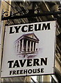
Lyceum Tavern name sign, Newport
Hanging from a wall bracket here. http://www.geograph.org.uk/photo/3312876 The sign depicts the now demolished Lyceum Theatre, a grand building in the Classical syle, which formerly graced the corner of Bridge Street and Station Street in the centre of Newport. The building was demolished c1961.
Image: © Jaggery
Taken: 15 Nov 2015
0.02 miles
3
Lyceum Tavern, 110 Malpas Road, Crindau, Newport
Pub on the corner of Jewell Lane viewed in May 2019. Kelly's Directory of Monmouthshire 1901 edition records that 110 Malpas Road was a grocer's shop at the start of the 20th century. At that time, this was about as far as buildings reached along Malpas Road from the town centre.
Image: © Jaggery
Taken: 27 May 2019
0.02 miles
4
Unnamed business premises on the corner of Malpas Road and Jewell Lane, Newport
At the mid-July 2013 date of this view, there was no nameboard on the funeral directors' premises.
On the other corner of Jewell Lane is the Lyceum Tavern. http://www.geograph.org.uk/photo/3312876
Image: © Jaggery
Taken: 17 Jul 2013
0.02 miles
5
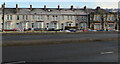
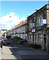
Row of houses and a pub, Malpas Road, Crindau, Newport
Viewed across the A4051 Malpas Road in January 2021.
Lyceum Tavern on the right is on the corner of Jewell Lane.
Image: © Jaggery
Taken: 10 Jan 2021
0.02 miles
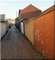
7
Jewell Lane, Newport
To the left is Lyceum Tavern http://www.geograph.org.uk/photo/1636963 , to the right is Signz and Michael G Ryan. http://www.geograph.org.uk/photo/1637684
Jewell Lane connects Malpas Lane with Malpas Road.
Image: © Jaggery
Taken: 28 Dec 2009
0.02 miles
8
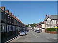
Ross Street, Newport
Houses on the east side of Ross Street, viewed from the Pant Road end looking towards Aston Crescent and Brynglas Road.
Image: © Jaggery
Taken: 20 Feb 2010
0.02 miles
9
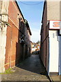
Malpas Lane, Newport
Looking along Malpas Lane from the corner of Pant Road. Malpas Lane runs parallel with, and between, Ross Street and Malpas Road.
Image: © Jaggery
Taken: 20 Feb 2010
0.02 miles
10
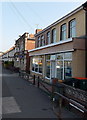
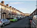
Business premises under scaffolding, 106-108 Malpas Road, Crindau, Newport
The premises of Michael G Ryan Son & Daughters Ltd on the corner of Jewell Lane viewed on May 27th 2019.
Image: © Jaggery
Taken: 27 May 2019
0.02 miles