IMAGES TAKEN NEAR TO
Blaen Y Pant Crescent, NEWPORT, NP20 5QA
Introduction
This page details the photographs taken nearby to Blaen Y Pant Crescent, NP20 5QA by members of the Geograph project.
The Geograph project started in 2005 with the aim of publishing, organising and preserving representative images for every square kilometre of Great Britain, Ireland and the Isle of Man.

There are currently over 7.5m images from over14,400 individuals and you can help contribute to the project by visiting https://www.geograph.org.uk
Image Map
Images are licensed for reuse under creativecommons.org/licenses/by-sa/2.0
Notes
- Clicking on the map will re-center to the selected point.
- The higher the marker number, the further away the image location is from the centre of the postcode.
Image Listing (525 Images Found)
Images are licensed for reuse under creativecommons.org/licenses/by-sa/2.0
Image
Details
Distance
1
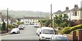
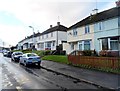
Blaen-y-Pant Avenue, Newport
Looking SW along Blaen-y-Pant Avenue, from the Malpas Road end.
Image: © Jaggery
Taken: 18 Sep 2009
0.02 miles
2
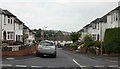
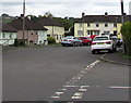
Looking down Blaen-y-Pant Place, Newport
Blaen-y-Pant Place is a short street of 12 houses between Blaen-y-Pant Crescent and Blaen-y-Pant Avenue. This view is from the Crescent end of the street.
Image: © Jaggery
Taken: 10 Jul 2010
0.02 miles
3
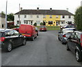
Southern end of Blaen-y-Pant Avenue, Newport
Houses at the southern end of the avenue, viewed from near the turning for Blaen-y-Pant Place.http://www.geograph.org.uk/photo/1956503
Image: © Jaggery
Taken: 10 Jul 2010
0.02 miles
4
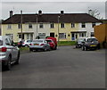
Row of houses at the SW end of Blaen-y-pant Avenue, Newport
Southwest of the Blaen-y-pant Place junction.
Image: © Jaggery
Taken: 3 May 2020
0.04 miles
5
Blaen-y-pant Crescent houses, Newport
Viewed from the edge of Kimberley Nursery School. http://www.geograph.org.uk/photo/3237985
Image: © Jaggery
Taken: 25 Nov 2012
0.04 miles
6
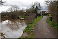
Monmouthshire and Brecon Canal near Crindau Park
Image: © Philip Halling
Taken: 12 Apr 2013
0.05 miles
7
![Gwastad Lock [1]](https://s2.geograph.org.uk/geophotos/01/88/89/1888946_a99f9687_120x120.jpg)
Gwastad Lock [1]
This is one of the locks that are operational for the 2010 Welsh Waterways Festival.
The boat is passing under Gwastad Bridge http://www.geograph.org.uk/photo/884625 on entry to the lock.
The need for some of the restoration work that has taken place on the canal can be seen in this picture taken two years ago http://www.geograph.org.uk/photo/884635 .
Image: © Robin Drayton
Taken: 31 May 2010
0.05 miles
8
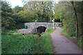
Gwastad Bridge, Monmouthshire & Brecon Canal
Bridge 26 immediately below a lock; the towpath carrying NCR 49 goes over the bridge.
Image: © M J Roscoe
Taken: 23 Oct 2018
0.05 miles
9
Dead-end part of Blaen-y-pant Avenue, Newport
Southwest of the Blaen-y-pant Place junction on the right.
Image: © Jaggery
Taken: 3 May 2020
0.05 miles
10
Monmouthshire and Brecon Canal
The Monmouthshire and Brecon Canal near Crindau Park.
Image: © Philip Halling
Taken: 12 Apr 2013
0.05 miles