IMAGES TAKEN NEAR TO
Malpas Road, NEWPORT, NP20 5PS
Introduction
This page details the photographs taken nearby to Malpas Road, NP20 5PS by members of the Geograph project.
The Geograph project started in 2005 with the aim of publishing, organising and preserving representative images for every square kilometre of Great Britain, Ireland and the Isle of Man.

There are currently over 7.5m images from over14,400 individuals and you can help contribute to the project by visiting https://www.geograph.org.uk
Image Map
Images are licensed for reuse under creativecommons.org/licenses/by-sa/2.0
Notes
- Clicking on the map will re-center to the selected point.
- The higher the marker number, the further away the image location is from the centre of the postcode.
Image Listing (702 Images Found)
Images are licensed for reuse under creativecommons.org/licenses/by-sa/2.0
Image
Details
Distance
1
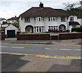
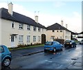
Semis on the corner of Blaen-y-pant Crescent and Malpas Road, Newport
The name sign shows Blaen-y-pant Crescent whereas the semi-detached houses are numbered in the Malpas Road sequence. Double yellow lines on both sides of the road indicate no parking at any time.
Image: © Jaggery
Taken: 1 Jun 2016
0.00 miles
2

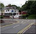
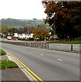
Junction of Malpas Road and Blaen-y-pant Crescent, Newport
Viewed across the dual carriageway A4051 Malpas Road.
PARTH on the sign on the left is Welsh for ZONE.
Image: © Jaggery
Taken: 26 Apr 2020
0.01 miles
3
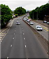
Three lanes and two lanes, Malpas Road, Newport
Heading away from M4 motorway junction 26, the northbound carriageway of the A4051 Malpas Road has three lanes. The other carriageway has two lanes.
Image: © Jaggery
Taken: 3 May 2020
0.01 miles
4
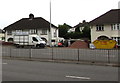
Gemini van, Malpas Road, Newport
Gemini Windows & Home Improvements is based in Yew Tree Lane, Caerleon.
Image: © Jaggery
Taken: 1 Nov 2016
0.01 miles
5
Junction of Blaen-y-pant Crescent and Malpas Road, Newport
The sign and road marking show left turn only. A vehicle turning right here
would be heading into oncoming traffic on the dual carriageway A4051 Malpas Road.
Image: © Jaggery
Taken: 1 Jun 2016
0.01 miles
6
Blaen-y-pant Crescent houses near Malpas Road, Newport
Looking towards Malpas Road from the edge of Kimberley Nursery School. http://www.geograph.org.uk/photo/3237985
Image: © Jaggery
Taken: 25 Nov 2012
0.02 miles
7
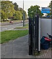
Railings between the carriageways of the A4051 Malpas Road, Newport
The railings start south of the Bettws Lane junction. The stump of a former lamppost is on the right.
Image: © Jaggery
Taken: 1 Nov 2016
0.02 miles
8
Vote Conservative placard, Malpas Road, Newport
The placard on display on April 29th 2022 shows "VOTE CONSERVATIVE. Build Back Malpas". This area is in the Malpas Ward in the City of Newport. There will be elections to all wards in all Welsh county & county borough councils and town & community councils next Thursday (May 5th 2022).
Image: © Jaggery
Taken: 29 Apr 2022
0.02 miles
9
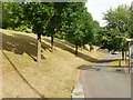
Tree-lined steep bank, Malpas Road, Newport
This is a short gap in the houses along the east side of Malpas Road, opposite the
Blaen-y-Pant Crescent junction. The land rises steeply towards Brynglas.
The grey wall of the next house can be seen in the middle distance. The next few houses are set several metres above road level, and each house has a long series of winding steps leading up from the pavement.
Image: © Jaggery
Taken: 10 Jul 2010
0.03 miles
10
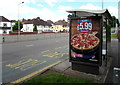
Domino's Pizza advert on a Malpas Road bus shelter, Newport
The advert is on a JCDecaux advertising site on the bus shelter opposite the Blaen-y-pant Crescent junction. JCDecaux is the largest outdoor advertising corporation in the world.
Image: © Jaggery
Taken: 6 Jul 2016
0.03 miles