1
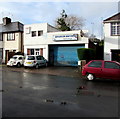
Brooklyn Motors, Crindau, Newport
Located in Pant Road near M4 motorway junction 26.
Image: © Jaggery
Taken: 3 Jan 2016
0.01 miles
2
The far end of Pant Road, Crindau, Newport
A few metres beyond the end of the street is the M4 motorway.
Image: © Jaggery
Taken: 26 Feb 2010
0.01 miles
3
NE along Pant Road, Newport
Looking to the northeast past lockup garages. Pant Road leads to Malpas Lane and Ross Street.
The far end of Pant Road is at the edge of the M4 motorway.
Image: © Jaggery
Taken: 17 Feb 2020
0.01 miles
4
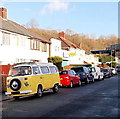
VW Camper van, Crindau, Newport
A yellow Volkswagen Camper van is parked in Pant Road.
In the background is part of a grey gantry across the M4 motorway.
Image: © Jaggery
Taken: 27 Jan 2013
0.03 miles
5
Smoke billows from the Brynglas tunnels, M4, Newport
Viewed from the Junction 26 roundabout, Malpas Rd. A lorry was on fire in the tunnel.
Image: © John Lord
Taken: 26 Jul 2011
0.03 miles
6
Pant Road turning circle, Crindau, Newport
At the northeast end of the road, 200 metres from the Malpas Road junction.
Image: © Jaggery
Taken: 3 Jan 2016
0.03 miles
7
Corner of Pant Road and Ross Street, Crindau, Newport
Viewed across Pant Road.
Image: © Jaggery
Taken: 3 Jan 2016
0.04 miles
8
Newport : The M4 Motorway
The M4 Motorway heading eastbound as it passes through the Newport area and towards the Brynglas Tunnel.
Image: © Lewis Clarke
Taken: 11 Apr 2014
0.04 miles
9
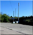
Telecoms mast and cabinets below the M4 motorway, Newport
Opposite the Christchurch Centre.
Image: © Jaggery
Taken: 19 Apr 2020
0.05 miles
10
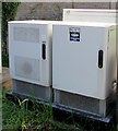
Thieves Beware notice on a telecoms cabinet, Newport
On the back of one of these https://www.geograph.org.uk/photo/6447006 cabinets in April 2020. The equipment is protected by SmartWater.
SmartWater is a colourless liquid that can be applied to property. The contents of each bottle contain a unique chemical code which is registered to the user, positively proving ownership. SmartWater is almost impossible to remove and cannot easily be seen by the naked eye. It glows under ultraviolet light, aiding forensic investigation.
Image: © Jaggery
Taken: 19 Apr 2020
0.05 miles


