IMAGES TAKEN NEAR TO
Walford Street, NEWPORT, NP20 5PG
Introduction
This page details the photographs taken nearby to Walford Street, NP20 5PG by members of the Geograph project.
The Geograph project started in 2005 with the aim of publishing, organising and preserving representative images for every square kilometre of Great Britain, Ireland and the Isle of Man.

There are currently over 7.5m images from over14,400 individuals and you can help contribute to the project by visiting https://www.geograph.org.uk
Image Map
Images are licensed for reuse under creativecommons.org/licenses/by-sa/2.0
Notes
- Clicking on the map will re-center to the selected point.
- The higher the marker number, the further away the image location is from the centre of the postcode.
Image Listing (1056 Images Found)
Images are licensed for reuse under creativecommons.org/licenses/by-sa/2.0
Image
Details
Distance
1
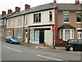
Aston Stores, Newport
13 Aston Crescent, on the corner of Ross Street. At the date of this photo, August 30th 2009, the Stores were vacant and to let.
Update : this photo http://www.geograph.org.uk/photo/1718377 taken in February 2010 shows that SMS Plan Printing are the new occupiers.
Image: © Jaggery
Taken: 30 Aug 2009
0.01 miles
2
Snack Shack, Brynglas Road, Newport
1A Brynglas Road. Sandwiches and baguettes.
Image: © Jaggery
Taken: 28 Dec 2009
0.01 miles
3
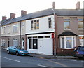
Signz and Ryan & Son Ltd, Malpas Road
Signz, 108 Malpas Road, sign makers, printers and graphic designers.
Michael G Ryan & Son Ltd, 106 Malpas Road, independent family funeral directors.
On the left is Jewell Lane http://www.geograph.org.uk/photo/1637697 and Lyceum Tavern. http://www.geograph.org.uk/photo/1636963
Image: © Jaggery
Taken: 28 Dec 2009
0.01 miles
4
SBS Plan Printing, Aston Crescent, Newport
A business providing copying, duplicating and secretarial services located at 13 Aston Crescent.
The premises were previously occupied by Aston Stores. http://www.geograph.org.uk/photo/1610587
Image: © Jaggery
Taken: 20 Feb 2010
0.01 miles
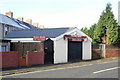
5

SE end of Malpas Lane, Newport
Malpas Lane heads northwestwards away from the corner of Aston Crescent and Brynglas Road.
On the right is Hair by Ken. http://www.geograph.org.uk/photo/1636262
Image: © Jaggery
Taken: 18 Aug 2010
0.01 miles
6
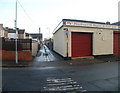
Northern side of Ross Lane, Newport
Ross Lane heads away from Goodrich Crescent, past the edge of Michael G Ryan & Son Ltd premises. http://www.geograph.org.uk/photo/1980987 to the view from the far end of the lane.
Image: © Jaggery
Taken: 12 Dec 2010
0.01 miles
7
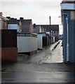
Ross Lane, Crindau, Newport
Between Malpas Road and Walford Street, Ross Lane is a short cut between
the northwest (this side) and southeast parts of Goodrich Crescent.
Image: © Jaggery
Taken: 3 Jan 2016
0.01 miles
8
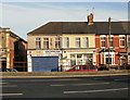
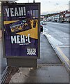
Malpas Road bus stop and shelter, Crindau, Newport
This stop is for buses from the city centre to the Bettws and Malpas areas of Newport.
Image: © Jaggery
Taken: 15 Nov 2015
0.03 miles
9
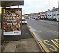
Kellogg's Fruit 'n' Fibre advert, Crindau, Newport
On display on a bus shelter alongside the A4051 Malpas Road on July 6th 2021.
Image: © Jaggery
Taken: 6 Jul 2021
0.03 miles
10
Cadbury advert on a Malpas Road bus shelter, Crindau, Newport
Cadbury Dairy Milk Banoffee Nut Crumble advert on display on August 9th 2021.
Image: © Jaggery
Taken: 9 Aug 2021
0.03 miles