IMAGES TAKEN NEAR TO
Goodrich Crescent, NEWPORT, NP20 5PF
Introduction
This page details the photographs taken nearby to Goodrich Crescent, NP20 5PF by members of the Geograph project.
The Geograph project started in 2005 with the aim of publishing, organising and preserving representative images for every square kilometre of Great Britain, Ireland and the Isle of Man.

There are currently over 7.5m images from over14,400 individuals and you can help contribute to the project by visiting https://www.geograph.org.uk
Image Map
Images are licensed for reuse under creativecommons.org/licenses/by-sa/2.0
Notes
- Clicking on the map will re-center to the selected point.
- The higher the marker number, the further away the image location is from the centre of the postcode.
Image Listing (993 Images Found)
Images are licensed for reuse under creativecommons.org/licenses/by-sa/2.0
Image
Details
Distance
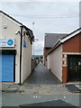
1
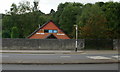
Malpas Brook Health Centre, Newport
Located at 107 Malpas Road, set back from, and below the level of, the main road.
https://www.geograph.org.uk/photo/5981559 to a closer view.
Image: © Jaggery
Taken: 16 Aug 2009
0.01 miles
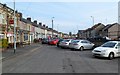
2
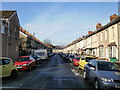
Walford Street, Newport
Walford Street extends from the south side to the north side of Goodrich Crescent. This is the view looking northwestwards. http://www.geograph.org.uk/photo/1636944 to the view from the other end.
Image: © Jaggery
Taken: 28 Dec 2009
0.01 miles
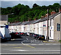
3
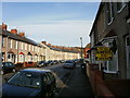
Goodrich Crescent, Newport
The northwest section of Goodrich Crescent.
As expected, there are many more houses on the outer (odd-numbered) side of the crescent than on the inner (even-numbered) side. Highest odd-numbered house is 133 ; highest even-numbered is 36.
Image: © Jaggery
Taken: 28 Dec 2009
0.01 miles
4
Dunn & Dyer, Newport
Among the houses on Goodrich Crescent, at 105 are the premises of Dunn & Dyer (Electrical) Ltd - electricians and electrical contractors.
Image: © Jaggery
Taken: 28 Dec 2009
0.01 miles
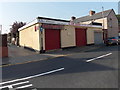
5
Ross Lane, Newport
Viewed from the southern arm of Goodrich Crescent. Ross Lane runs between Malpas Road and Walford Street, and exits into the northern arm of Goodrich Crescent, about 200 metres away.
On the left is a training suite. http://www.geograph.org.uk/photo/1980972
Image: © Jaggery
Taken: 25 Jul 2010
0.01 miles
6
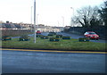
Malpas Road (A4051) south of M4 motorway, Newport
Malpas Road heads away from M4 motorway junction 26, towards central Newport.
The dozen or so empty containers, in the colours of Newport City Council, are used for floral displays during the warmer months.
Image: © Jaggery
Taken: 12 Dec 2010
0.01 miles
7
Blocked end of (old) Malpas Road, Crindau, Newport
The cars are parked alongside a wall bordering the present-day course of Malpas Road. Before the construction of the M4 through Newport and the realignment of Malpas Road adjacent to M4 junction 26, this was the route of Malpas Road. The Lyceum Tavern is on the left. http://www.geograph.org.uk/photo/1636963
Image: © Jaggery
Taken: 16 Apr 2012
0.01 miles
8
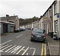
One-way sign, Goodrich Crescent, Crindau, Newport
Ahead for the Walford Street junction.
Image: © Jaggery
Taken: 6 Jan 2020
0.02 miles
9
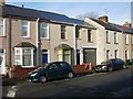
Goodrich Crescent houses, Crindau, Newport
Viewed across the A4051 Malpas Road.
Image: © Jaggery
Taken: 27 May 2019
0.02 miles
10
Lilys Flowers and Glam Shack, Newport
These two business premises in Goodrich Crescent have had various occupiers in recent years.
This mid-July 2013 view shows a florist shop on the left and a hair & beauty salon on the right.
Image: © Jaggery
Taken: 17 Jul 2013
0.03 miles