IMAGES TAKEN NEAR TO
Albany Street, NEWPORT, NP20 5NJ
Introduction
This page details the photographs taken nearby to Albany Street, NP20 5NJ by members of the Geograph project.
The Geograph project started in 2005 with the aim of publishing, organising and preserving representative images for every square kilometre of Great Britain, Ireland and the Isle of Man.

There are currently over 7.5m images from over14,400 individuals and you can help contribute to the project by visiting https://www.geograph.org.uk
Image Map
Images are licensed for reuse under creativecommons.org/licenses/by-sa/2.0
Notes
- Clicking on the map will re-center to the selected point.
- The higher the marker number, the further away the image location is from the centre of the postcode.
Image Listing (421 Images Found)
Images are licensed for reuse under creativecommons.org/licenses/by-sa/2.0
Image
Details
Distance
1
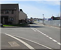
Junction of The Turnstiles and Albany Street, Crindau, Newport
From the left, The Turnstiles joins Albany Street in the Crindau area of Newport. Houses in the cul-de-sac named The Turnstiles are on the site formerly occupied by Rexville, the football ground of Lovell's Athletic F.C., founded in 1918, disbanded in 1969.
Image: © Jaggery
Taken: 7 Apr 2020
0.02 miles
2
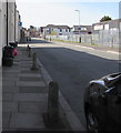
Concrete posts on the east side of Albany Street, Crindau, Newport
On the pavement outside a row of houses located between
the Turnstiles junction and the Alderney Street junction (ahead).
Image: © Jaggery
Taken: 7 Apr 2020
0.02 miles
3
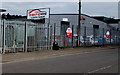
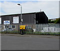
Albany Street electricity substation near Right Cars, Crindau, Newport
On the left, the dark green cabinet behind the fence is a Western Power Distribution electricity substation.
Its identifier is ALBANY STREET NEWPORT S/S No. 53-6850.
Image: © Jaggery
Taken: 9 May 2017
0.02 miles
4
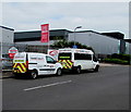
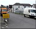
Two Highway Maintenance vans in Albany Street, Crindau, Newport
Both vans are part of the Thames Valley Construction & Civil Engineering Ltd fleet.
The Thames Valley office http://www.geograph.org.uk/photo/4094423 is nearby.
Image: © Jaggery
Taken: 9 May 2017
0.02 miles
5
Bilingual Gwyriad/Diversion sign, Albany Street, Crindau, Newport
The Welsh/English sign faces Alderney Street in May 2017 because part of nearby Lyne Road is closed. http://www.geograph.org.uk/photo/5379332
Image: © Jaggery
Taken: 9 May 2017
0.02 miles
6
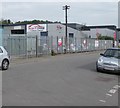
Autounit, Albany Industrial Estate, Crindau, Newport
Autounit used car dealer viewed across Albany Street in April 2020.
Image: © Jaggery
Taken: 7 Apr 2020
0.02 miles
7
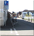
Priority over oncoming vehicles sign, Albany Street, Crindau, Newport
The text on the sign on the corner of Alderney Street is also in Welsh.
Image: © Jaggery
Taken: 7 Apr 2020
0.02 miles
8
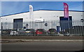
Right Cars Online, Crindau, Newport
Used cars dealership viewed across Albany Street from the corner of Alderney Street.
Image: © Jaggery
Taken: 9 May 2017
0.02 miles
9
Follow diversion sign in Crindau, Newport
The bilingual (Welsh/English) temporary sign is on the corner of Alderney Street and Albany Street in May 2017 while part of nearby Lyne Road is closed. http://www.geograph.org.uk/photo/5379332
Image: © Jaggery
Taken: 9 May 2017
0.03 miles
10
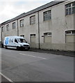
DPD Local van in Alderney Street, Crindau, Newport
DPD Local is a parcels delivery business.
Image: © Jaggery
Taken: 9 May 2017
0.03 miles