IMAGES TAKEN NEAR TO
Ailesbury Street, NEWPORT, NP20 5ND
Introduction
This page details the photographs taken nearby to Ailesbury Street, NP20 5ND by members of the Geograph project.
The Geograph project started in 2005 with the aim of publishing, organising and preserving representative images for every square kilometre of Great Britain, Ireland and the Isle of Man.

There are currently over 7.5m images from over14,400 individuals and you can help contribute to the project by visiting https://www.geograph.org.uk
Image Map
Images are licensed for reuse under creativecommons.org/licenses/by-sa/2.0
Notes
- Clicking on the map will re-center to the selected point.
- The higher the marker number, the further away the image location is from the centre of the postcode.
Image Listing (1199 Images Found)
Images are licensed for reuse under creativecommons.org/licenses/by-sa/2.0
Image
Details
Distance
1
Northern end of Ailesbury Street, Crindau, Newport
Viewed from Aragon Street.
Image: © Jaggery
Taken: 25 Dec 2013
0.02 miles
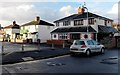
2
West side of Ailesbury Street, Crindau, Newport
Viewed from the corner of Aragon Street.
Image: © Jaggery
Taken: 9 May 2017
0.03 miles
3
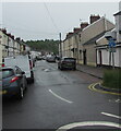
North along Ailesbury Street, Crindau, Newport
Towards Aragon Street. Albany Street is behind the camera.
White-on-blue National Cycle Network Route 88 direction signs are on the right.
Image: © Jaggery
Taken: 28 May 2021
0.03 miles
4
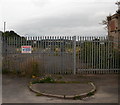
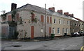
Kestrel Guards Aragon Street, Crindau, Newport
The top end of Aragon St, just before the footpath under the A4042 to Redland Street. The site appears to be using an alternative to guard dogs. The edge of the bricked up building http://www.geograph.org.uk/photo/1447474 is to the right
Image: © Jaggery
Taken: 16 Aug 2009
0.03 miles
5
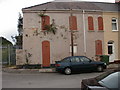
Aragon Street Crindau
Aragon Street,Crindau, near the junction with Ailesbury Street. The bricked-up building is the former gas company offices, on the corner of an extensive former gas company site which extended to the north east, reaching almost to Glassworks Cottages. It is likely to have become derelict on the closure of the gas site in 1969. The primary stone,visible above the car, was laid on June 17th 1884. See http://www.geograph.org.uk/photo/1447497 for full text on the stone.
Image: © Jaggery
Taken: 16 Aug 2009
0.03 miles
6
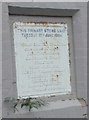
Primary Stone, Aragon Street
The primary stone was laid on June 17th 1884. It is in the now derelict former gas company offices http://www.geograph.org.uk/photo/1447474 at the western end of Aragon Street, Crindau. Full text on the stone :
THIS PRIMARY STONE LAID
TUESDAY 17TH JUNE 1884
BY
THOMAS GRATREX ESQ., J.P., D.L.
CHAIRMAN OF GAS CO.
DEPUTY-CHAIRMAN,
E.J. PHILLIPS ESQ., J.P.
DIRECTORS,
HENRY FARR ESQ.,
JOSEPH FIRBANK ESQ., J.P.
T.L.BREWER ESQ., J.P.
B.G. BLEW ESQ.
SECRETARY E.F.MARFLEET
ENGINEER THOMAS CANNING, C.E.
Image: © Jaggery
Taken: 16 Aug 2009
0.03 miles
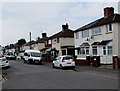
7
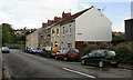
Aragon Street houses, Crindau, Newport
Houses on the east side of the street, near the Ailesbury Street end. Crindau Junior School is on the other side of the street. There are business premises on
both sides of the street at the Albany Street end.
The bricked-up building was once gas company offices http://www.geograph.org.uk/photo/1447474
Image: © Jaggery
Taken: 27 Aug 2009
0.03 miles
8
Aragon Street, Crindau, Newport
The view from the corner of Argyle Street. Crindau Junior School is on the other side of Aragon Street.
Image: © Jaggery
Taken: 27 Aug 2009
0.03 miles
9
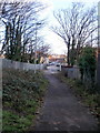
Path from underpass to Aragon Street, Crindau
The path connects an underpass http://www.geograph.org.uk/photo/1644883 beneath the A4042, with Aragon Street (directly ahead) and Ailesbury Street.
Image: © Jaggery
Taken: 3 Jan 2010
0.03 miles
10
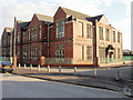
Crindau Primary School, Newport
Viewed from the corner of Ailesbury Street and Aragon Street.
The school, built in 1901, currently has about 300 pupils.
Image: © Jaggery
Taken: 20 Feb 2010
0.03 miles