IMAGES TAKEN NEAR TO
Brynglas Crescent, NEWPORT, NP20 5LT
Introduction
This page details the photographs taken nearby to Brynglas Crescent, NP20 5LT by members of the Geograph project.
The Geograph project started in 2005 with the aim of publishing, organising and preserving representative images for every square kilometre of Great Britain, Ireland and the Isle of Man.

There are currently over 7.5m images from over14,400 individuals and you can help contribute to the project by visiting https://www.geograph.org.uk
Image Map
Images are licensed for reuse under creativecommons.org/licenses/by-sa/2.0
Notes
- Clicking on the map will re-center to the selected point.
- The higher the marker number, the further away the image location is from the centre of the postcode.
Image Listing (852 Images Found)
Images are licensed for reuse under creativecommons.org/licenses/by-sa/2.0
Image
Details
Distance
1
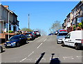
Up Brynglas Crescent, Newport
From Brynglas Avenue, Brynglas Crescent ascends towards Crindau Road.
Image: © Jaggery
Taken: 15 Apr 2020
0.01 miles
2
North side of Brynglas Crescent, Newport
Viewed from Crindau Road. Brynglas Crescent extends for 50 metres towards the Brynglas Avenue and Redland Street junction.
Image: © Jaggery
Taken: 30 Dec 2014
0.01 miles
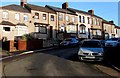
3

Brynglas Crescent houses, Newport
Houses on the south side of Brynglas Crescent viewed from Brynglas Avenue.
Image: © Jaggery
Taken: 15 Apr 2020
0.02 miles
4
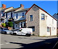
House on the corner of Brynglas Crescent and Brynglas Avenue, Newport
The vehicles are parked in Brynglas Crescent. At this junction, Redland Street on the camera side becomes Brynglas Avenue. Nearby, 114 Redland Street is next door to 2 Brynglas Avenue in the same row of houses.
Image: © Jaggery
Taken: 15 Apr 2020
0.02 miles
5
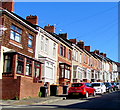
West side of Redland Street, Newport
Row of houses north of the Spring Street junction on the ascent towards Brynglas Avenue.
Image: © Jaggery
Taken: 15 Apr 2020
0.02 miles
6

King George V pillarbox, Brynglas Avenue, Newport
Located here https://www.geograph.org.uk/photo/6444471 near the corner of Brynglas Crescent. The GR on the box is short for Georgius Rex, Latin for King George, in this case King George V who reigned from May 1910-January 1936.
Image: © Jaggery
Taken: 15 Apr 2020
0.03 miles
7
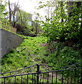
Track above Brynglas Road, Newport
Grassy track ascending from the east side of Brynglas Road.
Image: © Jaggery
Taken: 13 Apr 2020
0.03 miles
8
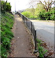
Up an elevated pavement, Brynglas Road, Newport
On the east side of the road.
Image: © Jaggery
Taken: 13 Apr 2020
0.04 miles
9
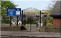
Church entrance gates, Brynglas Road, Newport
Entrance to All Saints' Community Church. https://www.geograph.org.uk/photo/6443117
Image: © Jaggery
Taken: 13 Apr 2020
0.04 miles
10
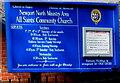
Church information board, Brynglas Road, Newport
Outside All Saints' Community Church. https://www.geograph.org.uk/photo/6443117
Image: © Jaggery
Taken: 13 Apr 2020
0.04 miles