IMAGES TAKEN NEAR TO
Albany Street, NEWPORT, NP20 5JL
Introduction
This page details the photographs taken nearby to Albany Street, NP20 5JL by members of the Geograph project.
The Geograph project started in 2005 with the aim of publishing, organising and preserving representative images for every square kilometre of Great Britain, Ireland and the Isle of Man.

There are currently over 7.5m images from over14,400 individuals and you can help contribute to the project by visiting https://www.geograph.org.uk
Image Map
Images are licensed for reuse under creativecommons.org/licenses/by-sa/2.0
Notes
- Clicking on the map will re-center to the selected point.
- The higher the marker number, the further away the image location is from the centre of the postcode.
Image Listing (1212 Images Found)
Images are licensed for reuse under creativecommons.org/licenses/by-sa/2.0
Image
Details
Distance
1
Argyle Street Newport
Argyle Street at the junction with Albany Street. But there is a confusion here http://www.geograph.org.uk/photo/1442962
Image: © Jaggery
Taken: 13 Aug 2009
0.01 miles
2
Newport . Argyll St or Argyle St
The street signs here are not in agreement. The older one, high on the wall, shows Argyll whereas the newer one at street level shows Argyle. Ordnance Survey maps show Argyle. Kelly's 1901 Newport street directory shows Argyll, so it seems that a change was made some time in the 20th century but the old sign was left in place. I do not know the reason for the change. It was not a geographically-aware local council following a change elsewhere, because the spelling of Argyll in Scotland went the other way. Currently it's Argyll, formerly Argyle.
Image: © Jaggery
Taken: 13 Aug 2009
0.01 miles
3
Boilermakers' Club, Crindau, Newport
13 Albany Street, on the corner of Ailesbury Street, Crindau
Image: © Jaggery
Taken: 28 Dec 2009
0.01 miles
4
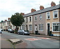
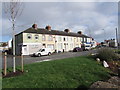
Middle section of Argyle Street, Crindau, Newport
Houses on the west side of the street. The view is looking towards Albany Street.
Image: © Jaggery
Taken: 13 Jul 2011
0.01 miles
5
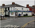
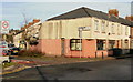
SA Convenience Store, Crindau, Newport
Lifestyle Express store on the corner of Albany Street and Ailesbury Street.
Image: © Jaggery
Taken: 15 Nov 2015
0.01 miles
6
Albany Street houses, Newport
On the north side of Albany Street between Agincourt Street and Ailesbury Street.
Image: © Jaggery
Taken: 17 Feb 2020
0.01 miles
7
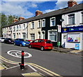
20 on Albany Road, Crindau, Newport
The 30mph speed limit on Lyne Road drops to 20mph ahead.
Image: © Jaggery
Taken: 27 May 2019
0.01 miles
8
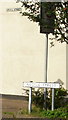
Diwedd y Parth/Zone ends, Albany Street, Crindau, Newport
The bilingual (Welsh/English) sign facing Albany Street shows that the 20mph
speed limit increases to 30mph on the approach to the Lyne Road junction.
Image: © Jaggery
Taken: 6 May 2017
0.01 miles
9
From 20 to 30 at the southern end of Ailesbury Street, Crindau, Newport
The 20mph speed limit in force near a primary school increases to 30mph.
Image: © Jaggery
Taken: 28 May 2021
0.01 miles
10

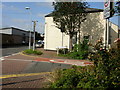
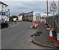
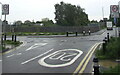
From 30 to 20 on Albany Street, Crindau, Newport
The speed limit drops to 20mph on the approach to Agincourt Street.
PARTH on the sign is Welsh for ZONE. The A4042 flyover is in the background.
Image: © Jaggery
Taken: 17 Feb 2020
0.01 miles