IMAGES TAKEN NEAR TO
Sudbury Walk, NEWPORT, NP20 5HU
Introduction
This page details the photographs taken nearby to Sudbury Walk, NP20 5HU by members of the Geograph project.
The Geograph project started in 2005 with the aim of publishing, organising and preserving representative images for every square kilometre of Great Britain, Ireland and the Isle of Man.

There are currently over 7.5m images from over14,400 individuals and you can help contribute to the project by visiting https://www.geograph.org.uk
Image Map
Images are licensed for reuse under creativecommons.org/licenses/by-sa/2.0
Notes
- Clicking on the map will re-center to the selected point.
- The higher the marker number, the further away the image location is from the centre of the postcode.
Image Listing (1086 Images Found)
Images are licensed for reuse under creativecommons.org/licenses/by-sa/2.0
Image
Details
Distance
1
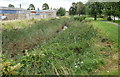
Crindau Pill, Newport
Locally, pill is the name given to a tidal inlet. This one, Crindau Pill, conveys the flow from Malpas Brook into the river Usk and at times receives salt water from the Usk when tides reverse the usual flow of the river.
Partly hidden by vegetation, Crindau Pill is here east of Malpas Road, west of Shaftesbury Park and at the northern edge of the area of streets sometimes known as The Marshes.
Image: © Jaggery
Taken: 4 Sep 2009
0.01 miles
2
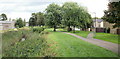
Footpath alongside Crindau Pill
The path runs along the bank of Crindau Pill http://www.geograph.org.uk/photo/1941272 between Lyne Road and Shaftesbury Park, with side paths to streets in the Shaftesbury area of Newport. This area is also referred to, especially formerly, as The Marshes.
Image: © Jaggery
Taken: 4 Sep 2009
0.01 miles
3
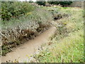
Muddy Crindau Pill, Newport
A pill is the local word for a tidal inlet. This view is near a 90-degree bend in Crindau Pill. Following recent very high tides in the River Usk, the water is muddy, but this has not deterred the ducks swimming near to the left bank.
Image: © Jaggery
Taken: 10 Sep 2010
0.01 miles
4
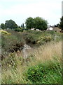
Bend in Crindau Pill, Newport
The course of the tidal inlet Crindau Pill here bends through 90 degrees. The three dark blobs in the pill are ducks swimming downstream (away from the camera).
Malpas Brook enters the River Usk through Crindau Pill, so the water at this point has varying degrees of salinity, depending on whether the flow is from the freshwater brook, or from the Bristol Channel via the Usk.
Image: © Jaggery
Taken: 10 Sep 2010
0.01 miles
5
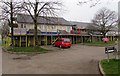
Tetbury Close scaffolding, Shaftesbury, Newport
Work in progress in April 2018 on the Shaftesbury Regeneration Scheme by
Westdale Services Limited on behalf of social landlord Newport City Homes.
Image: © Jaggery
Taken: 17 Apr 2018
0.01 miles
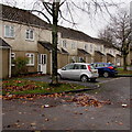
6
Tetbury Close, Crindau, Newport
Viewed from Ledbury Drive.
Image: © Jaggery
Taken: 14 Oct 2013
0.02 miles
7
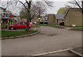
Tetbury Close, Newport
Viewed from Ledbury Drive. The name sign on the right shows that Tetbury Close leads to Sudbury Walk.
Image: © Jaggery
Taken: 15 Nov 2015
0.02 miles
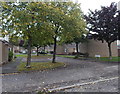
8
Tetbury Close houses, Newport
Viewed from the corner of Ledbury Drive.
Image: © Jaggery
Taken: 15 Nov 2015
0.02 miles
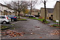
9
West along Tetbury Close, Shaftesbury, Newport
From Ledbury Drive, Tetbury Close leads to Sudbury Walk. Scaffolding on the left https://www.geograph.org.uk/photo/5742584 is in place in April 2018 during work in progress on the Shaftesbury Regeneration Scheme by Westdale Services Limited on behalf of social landlord Newport City Homes.
Image: © Jaggery
Taken: 17 Apr 2018
0.03 miles
10
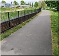
Path on the east side of Lyne Road, Newport
Ahead for Ledbury Drive.
Image: © Jaggery
Taken: 5 May 2022
0.03 miles