IMAGES TAKEN NEAR TO
Shaftesbury Walk, NEWPORT, NP20 5HN
Introduction
This page details the photographs taken nearby to Shaftesbury Walk, NP20 5HN by members of the Geograph project.
The Geograph project started in 2005 with the aim of publishing, organising and preserving representative images for every square kilometre of Great Britain, Ireland and the Isle of Man.

There are currently over 7.5m images from over14,400 individuals and you can help contribute to the project by visiting https://www.geograph.org.uk
Image Map
Images are licensed for reuse under creativecommons.org/licenses/by-sa/2.0
Notes
- Clicking on the map will re-center to the selected point.
- The higher the marker number, the further away the image location is from the centre of the postcode.
Image Listing (1089 Images Found)
Images are licensed for reuse under creativecommons.org/licenses/by-sa/2.0
Image
Details
Distance
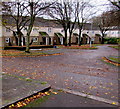
1
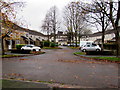
Malmesbury Close, Crindau, Newport
On the west side of Ledbury Drive.
Image: © Jaggery
Taken: 15 Nov 2015
0.01 miles
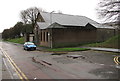
2
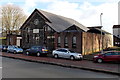
Shaftesbury Methodist Church, Newport
Located in Shaftesbury Street, between Malpas Road and the city centre.
In addition to religious services, the church is where the local U3A (University of the Third Age) meet, currently (January 2013) from 10am to 3.30pm each Wednesday, Thursday and Friday.
Image: © Jaggery
Taken: 27 Jan 2013
0.01 miles
3
Rear of Shaftesbury Methodist Church, Newport
Viewed from Shaftesbury Walk. The church is in use as a polling station https://www.geograph.org.uk/photo/7168671 today, Thursday May 5th 2022.
Image: © Jaggery
Taken: 5 May 2022
0.01 miles
4
Polling Station in a church, Shaftesbury, Newport
Shaftesbury Methodist Church is in use as a polling station on May 5th 2022. Elections to all wards in all Welsh county & county borough councils and town & community councils are taking place today.
Image: © Jaggery
Taken: 5 May 2022
0.02 miles
5
South side of Shaftesbury Methodist Church, Newport
Part of the Newport & Lower Wye Methodist Circuit,
the church is alongside a side road below the B4591.
Image: © Jaggery
Taken: 15 Feb 2020
0.02 miles
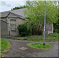
6
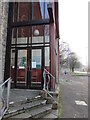
Entrance to Shaftesbury Methodist Church, Newport
A notice on a door of this church https://www.geograph.org.uk/photo/3313463 on Sunday January 10th 2021 shows
THERE WILL BE NO SERVICE AT SHAFTESBURY TODAY DUE TO COVID-19 RESTRICTIONS.
Image: © Jaggery
Taken: 10 Jan 2021
0.02 miles
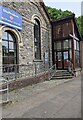
7
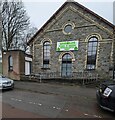
Recently opened Dawateislami Faizan-e-Madina Education Centre, Newport
Viewed in February 2024. The Islamic Education Centre opened here on January 22nd 2024.
https://www.geograph.org.uk/photo/7710094 to a closer view of the nameboard.
The building was previously Shaftesbury Methodist Church seen here https://www.geograph.org.uk/photo/1451180 in 2009.
Image: © Jaggery
Taken: 17 Feb 2024
0.02 miles
8

Green-on-white nameboard, Shaftesbury, Newport
The Dawateislami Faizan-e-Madina Education Centre nameboard is on the wall here. https://www.geograph.org.uk/photo/7710089
Image: © Jaggery
Taken: 17 Feb 2024
0.02 miles
9
Shrewsbury Close, Crindau, Newport
Viewed across Ledbury Drive.
Image: © Jaggery
Taken: 15 Nov 2015
0.02 miles
10

Polling station in Shaftesbury Methodist Church, Newport
On Thursday May 22nd 2014, the church is in use as a polling station
for the election of members of the European Parliament for the Wales region.
Image: © Jaggery
Taken: 22 May 2014
0.02 miles