IMAGES TAKEN NEAR TO
Queens Hill Crescent, NEWPORT, NP20 5HH
Introduction
This page details the photographs taken nearby to Queens Hill Crescent, NP20 5HH by members of the Geograph project.
The Geograph project started in 2005 with the aim of publishing, organising and preserving representative images for every square kilometre of Great Britain, Ireland and the Isle of Man.

There are currently over 7.5m images from over14,400 individuals and you can help contribute to the project by visiting https://www.geograph.org.uk
Image Map
Images are licensed for reuse under creativecommons.org/licenses/by-sa/2.0
Notes
- Clicking on the map will re-center to the selected point.
- The higher the marker number, the further away the image location is from the centre of the postcode.
Image Listing (759 Images Found)
Images are licensed for reuse under creativecommons.org/licenses/by-sa/2.0
Image
Details
Distance
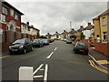
1
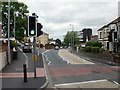
Queen's Hill , Newport
Looking northward along Queen's Hill. Queen's Hill Crescent is on the left.
Image: © Jaggery
Taken: 16 Aug 2009
0.03 miles
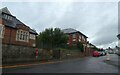
2
Mormon church viewed across Queen's Hill, Newport
The church entrance is from the far side, from Factory Road. http://www.geograph.org.uk/photo/1617433
The Mormons refer to themselves as members of The Church of Jesus Christ of Latter Day Saints.
Image: © Jaggery
Taken: 16 Apr 2012
0.03 miles
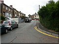
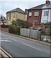
6
Queen's Hill Crescent, Newport
Viewed from the edge of Queen's Hill
Image: © Jaggery
Taken: 16 Aug 2009
0.05 miles
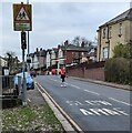
7
Queen's Hill bus stop sign, Newport
In January 2023 the stop on the right is used by a school bus service -
route JF3 Queen's Hill to John Frost School.
Image: © Jaggery
Taken: 28 Jan 2023
0.05 miles
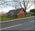
8
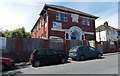
Kites Nurseries, Newport
Located at 3 Queens Hill Crescent, in a converted former Ashkenazi Orthodox Jewish synagogue.
The first record of a Jewish community in Newport was in the 19th century. At the start of the 20th century, Kelly's Directory of 1901 recorded that Newport's Jewish Synagogue was in Francis Street (in the Pill area). The synagogue moved here to Queens Hill Crescent in 1922 where a Hebrew School was also established. In the 1980s the synagogue moved to St Marks Crescent.
Image: © Jaggery
Taken: 8 Jun 2014
0.05 miles
9
Bilingual warning sign, Queen's Hill, Newport
Grimy in January 2023, the sign shows Patrol and the Welsh Hebryngwr.
A primary school is ahead.
Image: © Jaggery
Taken: 28 Jan 2023
0.05 miles
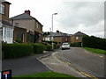
10
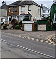
Two lockup garages, Queen's Croft, Newport
At the SE end of Queen's Croft, viewed across Queen's Hill.
Image: © Jaggery
Taken: 28 Jan 2023
0.05 miles