IMAGES TAKEN NEAR TO
St. Marks Crescent, NEWPORT, NP20 5HD
Introduction
This page details the photographs taken nearby to St. Marks Crescent, NP20 5HD by members of the Geograph project.
The Geograph project started in 2005 with the aim of publishing, organising and preserving representative images for every square kilometre of Great Britain, Ireland and the Isle of Man.

There are currently over 7.5m images from over14,400 individuals and you can help contribute to the project by visiting https://www.geograph.org.uk
Image Map
Images are licensed for reuse under creativecommons.org/licenses/by-sa/2.0
Notes
- Clicking on the map will re-center to the selected point.
- The higher the marker number, the further away the image location is from the centre of the postcode.
Image Listing (1004 Images Found)
Images are licensed for reuse under creativecommons.org/licenses/by-sa/2.0
Image
Details
Distance
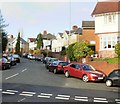
1
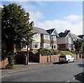
Trees and houses, St Mark's Crescent, Newport
The north side of St Mark's Crescent, east of the Queen's Hill Crescent junction. http://www.geograph.org.uk/photo/5080444
Image: © Jaggery
Taken: 17 Aug 2016
0.01 miles
2
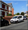
Keltbray white van in St Mark's Crescent, Newport
Their website states that the Keltbray Group is a UK leading specialist business, which offers engineering, construction, demolition, decommissioning, remediation, rail and environmental services. The company is a key player in developing and maintaining Britain's built environment and operates in highly regulated environments, making sites ready for new infrastructure and developments.
Image: © Jaggery
Taken: 17 Aug 2016
0.02 miles
3

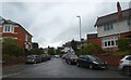
Up St Mark's Crescent, Newport
Opposite the Serpentine Road junction, St Mark's Crescent ascends from Fields Road.
Image: © Jaggery
Taken: 17 Aug 2016
0.02 miles
6
St Mark's Crescent, Newport
Houses on the east side of St Mark's Crescent, viewed from the corner of Fields Road and Serpentine Road.
Image: © Jaggery
Taken: 10 Dec 2009
0.04 miles
7
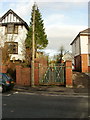
Former school entrance, St Mark's Crescent, Newport
Several decades ago, this was a side entrance to what was at that time a grammar school, Newport High School. The rusting gates and overgrown vegetation along the path suggest that this entrance is now disused.
Image: © Jaggery
Taken: 10 Dec 2009
0.04 miles
8
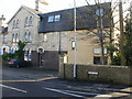
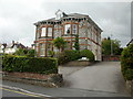
6 Gold Tops, Newport
The view from Gold Tops. See http://www.geograph.org.uk/photo/1614179 for the side view from Serpentine Road, and details of the occupiers.
Image: © Jaggery
Taken: 12 Dec 2009
0.04 miles
9
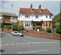
Corner of St Marks Crescent and Fields Road, Newport
The eastern corner of St Marks Crescent and Fields Road, viewed from Serpentine Road.
Image: © Jaggery
Taken: 25 Jul 2010
0.04 miles
10

On-street parking, Fields Road, Newport
Long line of parked cars on the north side of Fields Road, viewed from the corner of Serpentine Road.
Image: © Jaggery
Taken: 17 Aug 2016
0.06 miles