IMAGES TAKEN NEAR TO
Pentonville, NEWPORT, NP20 5HB
Introduction
This page details the photographs taken nearby to Pentonville, NP20 5HB by members of the Geograph project.
The Geograph project started in 2005 with the aim of publishing, organising and preserving representative images for every square kilometre of Great Britain, Ireland and the Isle of Man.

There are currently over 7.5m images from over14,400 individuals and you can help contribute to the project by visiting https://www.geograph.org.uk
Image Map
Images are licensed for reuse under creativecommons.org/licenses/by-sa/2.0
Notes
- Clicking on the map will re-center to the selected point.
- The higher the marker number, the further away the image location is from the centre of the postcode.
Image Listing (2301 Images Found)
Images are licensed for reuse under creativecommons.org/licenses/by-sa/2.0
Image
Details
Distance
1
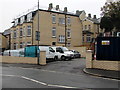
Queen's Hill housing construction, Newport
New housing looking nearly complete externally in early November 2015.
Image: © Jaggery
Taken: 4 Nov 2015
0.00 miles
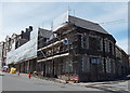
2
Fenced-off area of Queens Hill, Newport
Viewed from the corner of Locke Street in early June 2014.
It was unclear whether this was a demolition site or a building site.
Image: © Jaggery
Taken: 8 Jun 2014
0.01 miles
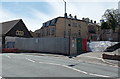
3
Exterior building work, Pentonville, Newport
Work in progress in early June 2014 on the corner of Pentonville and Queens Hill.
Image: © Jaggery
Taken: 8 Jun 2014
0.01 miles
4
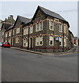
Stone building on the corner of Pentonville and Queen's Hill, Newport
The black arrow on the sign alongside Queen's Hill points the way to the M4 motorway and Cwmbran.
Image: © Jaggery
Taken: 13 Apr 2016
0.01 miles
5
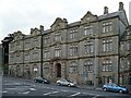
Shire Hall, Pentonville
Formerly county offices, now let as offices for a variety of purposes.
This is a Grade II listed building and is opposite to Image .
Image: © Robin Drayton
Taken: 13 Jun 2008
0.02 miles
6
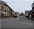
Queen's Hill, Newport
Queen's Hill ascends northwards from Pentonville.
The sign on the left points the way towards the M4 motorway and Cwmbran.
Image: © Jaggery
Taken: 13 Apr 2016
0.02 miles
7
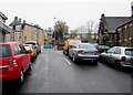
On-street parking at the top of Locke Street, Newport
Locke Street used to be a through route for motor vehicles from Factory Road to Queen's Hill (ahead).
In 2015, there are concrete posts across Locke Street behind the camera.
Image: © Jaggery
Taken: 4 Nov 2015
0.02 miles
8
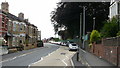
Queen's Hill , Newport
Looking south along Queen's Hill towards the junction with Locke Street.
Image: © Jaggery
Taken: 16 Aug 2009
0.02 miles
9
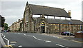
Locke Street Community Centre
Formerly a church, the community centre is on the corner of Queen's Hill and Locke Street.
Image: © Jaggery
Taken: 16 Aug 2009
0.02 miles
10

Newport Community Engagement Project, Pentonville, Newport
The right side of this semi-detached building is 8 Pentonville, premises of Newport Community Engagement Project. Officially launched in November 2007,
the project is aimed at individuals, families and communities who have been, or know someone who has been, affected by substance misuse.
Image: © Jaggery
Taken: 10 Dec 2009
0.02 miles