IMAGES TAKEN NEAR TO
Allt-yr-Yn Court, NEWPORT, NP20 5GF
Introduction
This page details the photographs taken nearby to Allt-yr-Yn Court, NP20 5GF by members of the Geograph project.
The Geograph project started in 2005 with the aim of publishing, organising and preserving representative images for every square kilometre of Great Britain, Ireland and the Isle of Man.

There are currently over 7.5m images from over14,400 individuals and you can help contribute to the project by visiting https://www.geograph.org.uk
Image Map
Images are licensed for reuse under creativecommons.org/licenses/by-sa/2.0
Notes
- Clicking on the map will re-center to the selected point.
- The higher the marker number, the further away the image location is from the centre of the postcode.
Image Listing (146 Images Found)
Images are licensed for reuse under creativecommons.org/licenses/by-sa/2.0
Image
Details
Distance
1
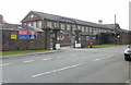
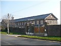
Territorial Army Centre, Newport
Viewed across Allt-yr-yn View, the former barracks are now officially styled TA Centre, 217 (City of Newport) Headquarters Battery Royal Artillery (Volunteers), a subunit of 104th Regiment Royal Artillery (Volunteers), Territorial Army.
The barracks date from 1845. The present-day roads around its perimeter are Barrack Hill, Bosworth Drive and Allt-yr-yn View. Kelly's Directory for Monmouthshire, 1901 states
"The barracks...can be used either by infantry or cavalry, and are at present occupied by the 133rd Battery Royal Field Artillery, Depot Battery Mountain Division and a detachment of Royal Northern Reserve, numbering in all 400 men."
Image: © Jaggery
Taken: 18 Sep 2009
0.03 miles
2
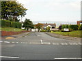
Allt-yr-yn Crescent, Newport
Allt-yr-yn Crescent heads away from Allt-yr-yn View. Ahead, on the left, is the turning for Allt-yr-yn Court.
Image: © Jaggery
Taken: 18 Sep 2009
0.03 miles
3
Change of house type, Allt-yr-yn View, Newport
The houses are opposite Raglan Barracks. http://www.geograph.org.uk/photo/706704
Image: © Jaggery
Taken: 17 Aug 2016
0.04 miles
4
Allt-yr-yn Crescent towards Allt-yr-yn Court, Newport
Looking across Allt-yr-yn View along Allt-yr-yn Crescent towards the Allt-yr-yn Court junction ahead on the left.
Image: © Jaggery
Taken: 17 Aug 2016
0.04 miles
5
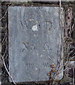
Raglan Barracks marker stone number 6, Newport
Located near the corner of Allt-yr-yn View, the stone is part of the western
perimeter wall of Raglan Barracks http://www.geograph.org.uk/photo/706704 viewed from this http://www.geograph.org.uk/photo/5078033 public footpath.
Image: © Jaggery
Taken: 17 Aug 2016
0.04 miles
6
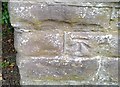
Ordnance Survey Cut Mark
This OS cut mark can be found on the wall of the Barracks. It marks a point 67.994m above mean sea level.
Image: © Adrian Dust
Taken: 17 Jun 2018
0.04 miles
7
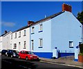
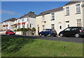
Shades of blue, Allt-yr-yn View, Newport
The dark blue edgings of the light blue house match the sky colour on August 17th 2016.
Image: © Jaggery
Taken: 17 Aug 2016
0.05 miles
8
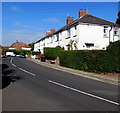
White houses, Allt-yr-yn View, Newport
On the north side of the road, near the Highcroft Road junction.
Image: © Jaggery
Taken: 17 Aug 2016
0.05 miles
10
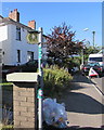
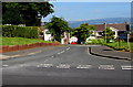
Public footpath signpost, Allt-yr-yn View, Newport
The signs points along this http://www.geograph.org.uk/photo/5078033 public footpath.
Image: © Jaggery
Taken: 17 Aug 2016
0.05 miles