IMAGES TAKEN NEAR TO
Canal Street, NEWPORT, NP20 5FL
Introduction
This page details the photographs taken nearby to Canal Street, NP20 5FL by members of the Geograph project.
The Geograph project started in 2005 with the aim of publishing, organising and preserving representative images for every square kilometre of Great Britain, Ireland and the Isle of Man.

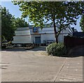
There are currently over 7.5m images from over14,400 individuals and you can help contribute to the project by visiting https://www.geograph.org.uk
Image Map
Images are licensed for reuse under creativecommons.org/licenses/by-sa/2.0
Notes
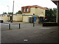
- Clicking on the map will re-center to the selected point.
- The higher the marker number, the further away the image location is from the centre of the postcode.
Image Listing (1172 Images Found)
Images are licensed for reuse under creativecommons.org/licenses/by-sa/2.0
Image
Details
Distance
1

Eastern end of Canal Street, Newport
A stone wall mostly covered with vegetation is across the Barrack Hill end of Canal Street.
Image: © Jaggery
Taken: 8 Sep 2016
0.00 miles
2
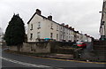
Houses on the east side of Dos Road, Newport
Viewed from Barrack Hill looking towards Canal Street.
Image: © Jaggery
Taken: 19 Dec 2013
0.02 miles
3
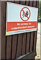
No access for unauthorised persons, Barrack Hill, Newport
The Savills Commercials Ltd notice refers to the yard https://www.geograph.org.uk/photo/6912367 on the north side of Aldi.
Image: © Jaggery
Taken: 26 Jul 2021
0.02 miles
4
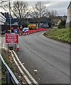
December 2022 roadworks, Barrack Hill, Newport
On December 3rd 2022 a temporary sign shows "WHEN RED LIGHT SHOWS WAIT HERE" and the Welsh equivalent.
The steep part of Barrack Hill is behind the camera.
Image: © Jaggery
Taken: 3 Dec 2022
0.02 miles
5
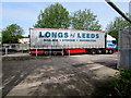
Longs of Leeds lorry in Crindau, Newport
Parked in the goods inward area between Malpas Road and Barrack Hill, on the north side of an Aldi store.
Image: © Jaggery
Taken: 19 May 2016
0.02 miles
6
North side of Aldi, Crindau, Newport
From Barrack Hill towards the yard and unloading area at the rear of Aldi supermarket.
Image: © Jaggery
Taken: 26 Jul 2021
0.02 miles
7
Coronation Working Men's Club, Albany Street, Newport
Located adjacent to the flyover carrying the A4042 Heidenheim Drive. The premises were recently modernised.
Image: © Jaggery
Taken: 23 Aug 2009
0.03 miles
8
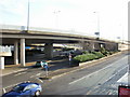
Two bridges, Malpas Road, Newport
In the foreground is a footbridge across Malpas Road ; in the background is the bridge carrying the A4042 (Heidenheim Drive). Newport has been twinned with Heidenheim in Baden Wurttemburg, Germany since 1980
Image: © Jaggery
Taken: 6 Sep 2009
0.03 miles
9

Crindau Christian Fellowship, Newport
2 Malpas Road, viewed from the footbridge across Malpas Road.
Image: © Jaggery
Taken: 28 Dec 2009
0.03 miles
10
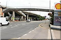
A4042 flyover, Malpas Road, Newport
The A4042 rises away from the Harlequin Roundabout over Malpas Road, which splits into two carriageways here. On the other side of the roundabout, the A4042 was Kingsway ; now it is named Heidenheim Drive. Newport has been twinned with Heidenheim in Baden Wurttemburg, Germany, since 1980
Image: © Jaggery
Taken: 28 Dec 2009
0.03 miles