IMAGES TAKEN NEAR TO
Mons Close, NEWPORT, NP20 5ET
Introduction
This page details the photographs taken nearby to Mons Close, NP20 5ET by members of the Geograph project.
The Geograph project started in 2005 with the aim of publishing, organising and preserving representative images for every square kilometre of Great Britain, Ireland and the Isle of Man.

There are currently over 7.5m images from over14,400 individuals and you can help contribute to the project by visiting https://www.geograph.org.uk
Image Map
Images are licensed for reuse under creativecommons.org/licenses/by-sa/2.0
Notes
- Clicking on the map will re-center to the selected point.
- The higher the marker number, the further away the image location is from the centre of the postcode.
Image Listing (129 Images Found)
Images are licensed for reuse under creativecommons.org/licenses/by-sa/2.0
Image
Details
Distance
1

Allt-yr-yn View, Newport
Houses on the north side of Allt-yr-yn View, between Highcroft Road (behind the camera) and Allt-yr-yn Crescent. Just visible on the right edge of the photo, next to the van in the middle of the road, is part of the perimeter wall of the TA Centre.http://www.geograph.org.uk/photo/1954452
Image: © Jaggery
Taken: 18 Sep 2009
0.03 miles
2
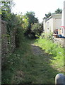
Public footpath in Allt-yr-yn, Newport
On the southeast side of Allt-yr-yn View. The western perimeter wall of Raglan Barracks http://www.geograph.org.uk/photo/706704 is on the left.
Image: © Jaggery
Taken: 17 Aug 2016
0.03 miles
3
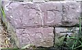
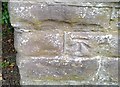
Ordnance Survey Cut Mark
This OS cut mark can be found on the War Department Marker Stone on the wall of the barracks. It marks a point 62.487m above mean sea level.
Image: © Adrian Dust
Taken: 17 Jun 2018
0.04 miles
4
Public footpath signpost, Allt-yr-yn View, Newport
The signs points along this http://www.geograph.org.uk/photo/5078033 public footpath.
Image: © Jaggery
Taken: 17 Aug 2016
0.04 miles
5
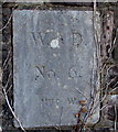
Raglan Barracks marker stone number 6, Newport
Located near the corner of Allt-yr-yn View, the stone is part of the western
perimeter wall of Raglan Barracks http://www.geograph.org.uk/photo/706704 viewed from this http://www.geograph.org.uk/photo/5078033 public footpath.
Image: © Jaggery
Taken: 17 Aug 2016
0.05 miles
6
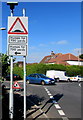
Warning sign - humps for 730 yards, Allt-yr-yn, Newport
Facing Allt-yr-yn View at the Highcroft Road junction.
Image: © Jaggery
Taken: 17 Aug 2016
0.05 miles
8
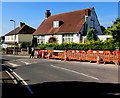
Speed bumps and temporary barriers, Highcroft Road, Allt-yr-yn, Newport
The barriers are at the edge of road resurfacing work. http://www.geograph.org.uk/photo/5078126
Image: © Jaggery
Taken: 17 Aug 2016
0.06 miles
9
Ordnance Survey Cut Mark
This OS cut mark can be found on the wall of the Barracks. It marks a point 67.994m above mean sea level.
Image: © Adrian Dust
Taken: 17 Jun 2018
0.06 miles
10
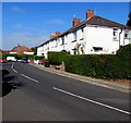
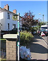
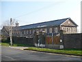
White houses, Allt-yr-yn View, Newport
On the north side of the road, near the Highcroft Road junction.
Image: © Jaggery
Taken: 17 Aug 2016
0.07 miles