IMAGES TAKEN NEAR TO
Evesham Court, NEWPORT, NP20 5EP
Introduction
This page details the photographs taken nearby to Evesham Court, NP20 5EP by members of the Geograph project.
The Geograph project started in 2005 with the aim of publishing, organising and preserving representative images for every square kilometre of Great Britain, Ireland and the Isle of Man.

There are currently over 7.5m images from over14,400 individuals and you can help contribute to the project by visiting https://www.geograph.org.uk
Image Map
Images are licensed for reuse under creativecommons.org/licenses/by-sa/2.0
Notes
- Clicking on the map will re-center to the selected point.
- The higher the marker number, the further away the image location is from the centre of the postcode.
Image Listing (298 Images Found)
Images are licensed for reuse under creativecommons.org/licenses/by-sa/2.0
Image
Details
Distance
1
Telecoms cabinet on a Barrack Hill corner, Newport
On the corner of Barrack Hill and Bosworth Drive.
Image: © Jaggery
Taken: 8 Sep 2016
0.01 miles
2
Flat top of Barrack Hill, Newport
Viewed from the corner of Allt-yr-yn Way. At the end of a long, steep ascent (towards the camera),
the western end of Barrack Hill is flat. Barrack Hill electricity substation http://www.geograph.org.uk/photo/5108578 is on the right.
Image: © Jaggery
Taken: 8 Sep 2016
0.02 miles
3
Warning sign - Playground /Lle chwarae, Barrack Hill, Newport
The bilingual (English/Welsh) warning sign is on the approach to this http://www.geograph.org.uk/photo/5108661 playground.
Image: © Jaggery
Taken: 8 Sep 2016
0.02 miles
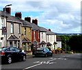
4
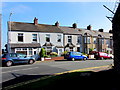
White semis, Barrack Hill,Newport
Two semi-detached houses opposite the Bosworth Drive junction. http://www.geograph.org.uk/photo/1954369
Image: © Jaggery
Taken: 8 Sep 2016
0.02 miles
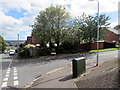
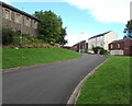
5
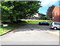
Evesham Court, Newport
Cul-de-sac on the west side of Bosworth Drive.
Image: © Jaggery
Taken: 8 Sep 2016
0.02 miles
6
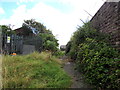
Overgrown path on the SE side of Barrack Hill, Newport
The path to Bosworth Drive passes an electricity substation http://www.geograph.org.uk/photo/5108578
on the left and the perimeter wall of Raglan Barracks on the right.
Image: © Jaggery
Taken: 8 Sep 2016
0.02 miles
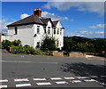
7
Western end of Barrack Hill, Newport
The row of houses is at the top end of Barrack Hill.
The barbed wire on the right is on top of the Raglan Barracks perimeter wall.
Image: © Jaggery
Taken: 17 Aug 2016
0.03 miles
8
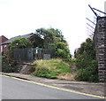
Barrack Hill electricity substation, Newport
The Western Power Distribution electricity substation is located at the top of Barrack Hill, opposite a barbed wire topped perimeter wall of Raglan Barracks. The substation identifier is BARRACK HILL S/S No 532252.
Image: © Jaggery
Taken: 8 Sep 2016
0.03 miles
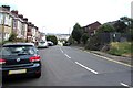
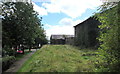
9
Bosworth Drive ascends towards Barrack Hill, Newport
An edge of Raglan Barracks is on the left.
Image: © Jaggery
Taken: 8 Sep 2016
0.03 miles
10
Path towards Bosworth Drive, Newport
Below a Raglan Barracks perimeter wall.
Image: © Jaggery
Taken: 8 Sep 2016
0.03 miles