IMAGES TAKEN NEAR TO
Ridgeway Place, NEWPORT, NP20 5DY
Introduction
This page details the photographs taken nearby to Ridgeway Place, NP20 5DY by members of the Geograph project.
The Geograph project started in 2005 with the aim of publishing, organising and preserving representative images for every square kilometre of Great Britain, Ireland and the Isle of Man.

There are currently over 7.5m images from over14,400 individuals and you can help contribute to the project by visiting https://www.geograph.org.uk
Image Map
Images are licensed for reuse under creativecommons.org/licenses/by-sa/2.0
Notes
- Clicking on the map will re-center to the selected point.
- The higher the marker number, the further away the image location is from the centre of the postcode.
Image Listing (123 Images Found)
Images are licensed for reuse under creativecommons.org/licenses/by-sa/2.0
Image
Details
Distance
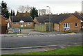
1
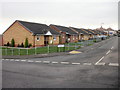
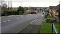
Ridgeway Park Road, Newport
Viewed from Ridgeway Hill. Modern bungalows along the south side, then, just visible in the distance, semi-detached 2-storey houses.
Image: © Jaggery
Taken: 12 Dec 2009
0.02 miles
2
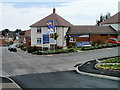
Bovis Sales Information Centre, Ridgeway Close, Newport
The Sales Centre is in Bryn Llonydd, a Bovis development of 2- 3- and 4-bedroom houses on the south side of Allt-yr-yn Avenue.
Image: © Jaggery
Taken: 25 Jul 2010
0.02 miles
3
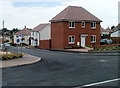
New housing, Ridgeway, Newport
These are some of the new houses built by Bovis in its Bryn Llonydd development on the south side of Allt-yr-yn Avenue.
Image: © Jaggery
Taken: 25 Jul 2010
0.02 miles
4
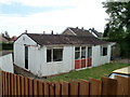
Possibly the only prefab remaining in Newport
A total of 750 prefabs (prefabricated bungalows) were erected in various parts of Newport to meet a severe housing shortage after the Second World War.
I had thought that all the prefabs in Newport had been demolished, but I was delighted to stumble upon this one on the edge of a new Bovis development on the south side of Allt-yr-yn Avenue. It has probably been kept for historical reasons. The accommodation looks very basic by modern standards, but compared with the unsanitary conditions in slums in the immediate postwar years of the mid to late 1940s, or the alternative of having to live in overcrowded existing housing, these prefabs must have been a highly desirable choice.
Image: © Jaggery
Taken: 25 Jul 2010
0.02 miles
5
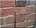
Ordnance Survey Cut Mark
This OS cut mark can be found on No36 Ridgeway Avenue. It marks a point 83.786m above mean sea level.
Image: © Adrian Dust
Taken: 29 Dec 2019
0.06 miles
6
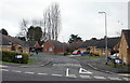
Ridgeway Hill, Newport
Looking down Ridgeway Hill from Allt-yr-yn Avenue. The fenced-off area on the left http://www.geograph.org.uk/photo/1616916 is a site awaiting redevelopment after demolition of prefabs.
Image: © Jaggery
Taken: 12 Dec 2009
0.06 miles
7
Ridgeway Rise, Newport
Modern bungalows, viewed from Ridgeway Hill.
Image: © Jaggery
Taken: 12 Dec 2009
0.06 miles
8
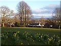
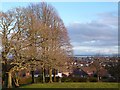
View southeast from Ridgeway, Newport
Looking across the city and Severn Estuary towards the North Somerset coast.
Image: © Robin Drayton
Taken: 8 Mar 2015
0.06 miles
9
View southeast from Ridgeway, Newport
Looking across the city and Severn Estuary towards the North Somerset coast.
Image: © Robin Drayton
Taken: 8 Mar 2015
0.06 miles
10
Ridgeway Reach, Newport
Modern bungalows, viewed from Ridgeway Hill.
Image: © Jaggery
Taken: 12 Dec 2009
0.07 miles