IMAGES TAKEN NEAR TO
Allt-yr-Yn Heights, NEWPORT, NP20 5DX
Introduction
This page details the photographs taken nearby to Allt-yr-Yn Heights, NP20 5DX by members of the Geograph project.
The Geograph project started in 2005 with the aim of publishing, organising and preserving representative images for every square kilometre of Great Britain, Ireland and the Isle of Man.

There are currently over 7.5m images from over14,400 individuals and you can help contribute to the project by visiting https://www.geograph.org.uk
Image Map
Images are licensed for reuse under creativecommons.org/licenses/by-sa/2.0
Notes
- Clicking on the map will re-center to the selected point.
- The higher the marker number, the further away the image location is from the centre of the postcode.
Image Listing (83 Images Found)
Images are licensed for reuse under creativecommons.org/licenses/by-sa/2.0
Image
Details
Distance
1
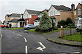
Allt-yr-yn Heights, Newport
Houses on the south side, near the Allt-yr-yn View junction.
Image: © Jaggery
Taken: 12 Dec 2009
0.02 miles
2
Allt-yr-yn Road, Newport
Houses on the south side of Allt-yr-yn Road, close to the Allt-yr-yn View junction.
Image: © Jaggery
Taken: 12 Dec 2009
0.04 miles
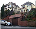
3
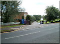
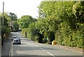
Allt-yr-yn View, Newport
This part of Allt-yr-yn View, between Allt-yr-yn Road and Allt-yr-yn Heights, runs alongside the southern edge of Allt-yr-yn Wood, and resembles a country road.
Image: © Jaggery
Taken: 12 Dec 2009
0.04 miles
4
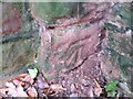
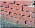
Ordnance Survey Cut Mark
This OS cut mark can be found on the old hospital wall SE side of Allt-yr-Yn View. It marks a point 81.075m above mean sea level.
Image: © Adrian Dust
Taken: 29 Dec 2019
0.04 miles
5
Ordnance Survey Cut Mark
This OS cut mark can be found on No54 Allt-yr-Yn Avenue. It marks a point 72.611m above mean sea level.
Image: © Adrian Dust
Taken: 29 Dec 2019
0.05 miles
6

Allt-yr-yn Close, Newport
Houses on the west side of a small triangular grassed area where Allt-yr-yn Close's orientation changes from northwestwards to northeastwards as it heads towards Allt-yr-yn Road.
Image: © Jaggery
Taken: 12 Dec 2009
0.06 miles
7
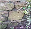
Ordnance Survey Cut Mark
This OS cut mark can be found on the old hospital wall SE side of Allt-yr-Yn View. It marks a point 72.564m above mean sea level.
Image: © Adrian Dust
Taken: 29 Dec 2019
0.08 miles
8
Entrance to Allt-yr-yn College, Newport
The entrance is from Allt-yr-yn Avenue into the Allt-yr-yn campus of the University of Wales, Newport
Image: © Jaggery
Taken: 25 Jul 2010
0.08 miles
9
Signs at the start of the entrance path to Allt-yr-yn Local Nature Reserve, Newport
Various signs inform the visitor to the nature reserve.
On the left side of the path, a sign states 'No motorcycles' and two small signs below it specify no dog fouling and no litter.
On the right side of the path, next to the Nature Reserve sign, a brown wooden sign points to a bridleway and there is another, larger, no dog fouling sign. Behind the camera a sign on a wooden post points towards National Cycle Route 47, and below it, a notice warns that even your dog can scare or harm farm animals - keep it on a lead near livestock.
Finally, a rock blocking half the width of the pathway makes a "no cars" sign unnecessary.
Image: © Jaggery
Taken: 18 Sep 2009
0.10 miles
10
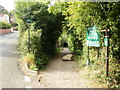
Entrance to Allt-yr-yn Local Nature Reserve
The entrance lane, from Allt-yr-yn View, starts on the right, a gap in the bushes just beyond the yellow gritting box.
Image: © Jaggery
Taken: 18 Sep 2009
0.10 miles