IMAGES TAKEN NEAR TO
Ridgeway Reach, NEWPORT, NP20 5AT
Introduction
This page details the photographs taken nearby to Ridgeway Reach, NP20 5AT by members of the Geograph project.
The Geograph project started in 2005 with the aim of publishing, organising and preserving representative images for every square kilometre of Great Britain, Ireland and the Isle of Man.

There are currently over 7.5m images from over14,400 individuals and you can help contribute to the project by visiting https://www.geograph.org.uk
Image Map
Images are licensed for reuse under creativecommons.org/licenses/by-sa/2.0
Notes
- Clicking on the map will re-center to the selected point.
- The higher the marker number, the further away the image location is from the centre of the postcode.
Image Listing (112 Images Found)
Images are licensed for reuse under creativecommons.org/licenses/by-sa/2.0
Image
Details
Distance
1

Ridgeway Reach bungalows, Newport
Bungalows in a cul-de-sac viewed across Ridgeway Hill.
A Ridgeway Reach name sign is on the left.
Image: © Jaggery
Taken: 2 Oct 2024
0.01 miles
2
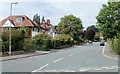
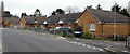
Fields Park Avenue, Newport
The view north along the western part of Fields Park Avenue, viewed from Fields Park Road.
Image: © Jaggery
Taken: 25 Jul 2010
0.04 miles
3
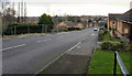
Ridgeway Hill, Newport
Looking down Ridgeway Hill from Allt-yr-yn Avenue. The fenced-off area on the left http://www.geograph.org.uk/photo/1616916 is a site awaiting redevelopment after demolition of prefabs.
Image: © Jaggery
Taken: 12 Dec 2009
0.07 miles
4
Ridgeway Rise, Newport
Modern bungalows, viewed from Ridgeway Hill.
Image: © Jaggery
Taken: 12 Dec 2009
0.07 miles
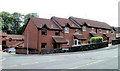
5
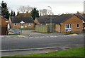
Ridgeway Reach, Newport
Modern bungalows, viewed from Ridgeway Hill.
Image: © Jaggery
Taken: 12 Dec 2009
0.07 miles
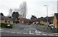
6
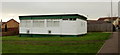
Ridgeway and Allt-yr-yn Community Centre, Newport
Set back about 20 metres from the west side of Ridgeway Hill.
Image: © Jaggery
Taken: 12 Dec 2009
0.07 miles
7
Looking up Ridgeway Hill, Newport
Bungalows on the east side of Ridgeway Hill, between Ridgeway Walk and Ridgeway Reach.
Image: © Jaggery
Taken: 12 Dec 2009
0.07 miles
8
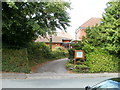
Entrance to Nant Coch church, Newport
The church http://www.geograph.org.uk/photo/1987139 is set back from the road and partly hidden by trees, so despite the name board outside, it's easy to miss the turning if you're not sure exactly where it is - which is on Fields Park Road, just a few metres west of the turning for Kings Acre and a few metres east of the turning for the western part of Fields Park Avenue.
Image: © Jaggery
Taken: 25 Jul 2010
0.07 miles
9
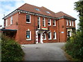
Nant Coch church, Newport
Located at 68 Fields Park Road. Nant Coch is an Evangelical Christian Fellowship which was formed in 1942. It met originally at Nant Coch House on Risca Road, now Rougemont School.
Image: © Jaggery
Taken: 25 Jul 2010
0.07 miles
10
1-5 Kings Acre, Newport
Kings Acre is a development of houses and flats built c1999 on the south side of Fields Park Road.
Seen here are 1-5 Kings Acre.
Image: © Jaggery
Taken: 25 Jul 2010
0.07 miles