IMAGES TAKEN NEAR TO
Ridgeway Walk, NEWPORT, NP20 5AS
Introduction
This page details the photographs taken nearby to Ridgeway Walk, NP20 5AS by members of the Geograph project.
The Geograph project started in 2005 with the aim of publishing, organising and preserving representative images for every square kilometre of Great Britain, Ireland and the Isle of Man.

There are currently over 7.5m images from over14,400 individuals and you can help contribute to the project by visiting https://www.geograph.org.uk
Image Map
Images are licensed for reuse under creativecommons.org/licenses/by-sa/2.0
Notes
- Clicking on the map will re-center to the selected point.
- The higher the marker number, the further away the image location is from the centre of the postcode.
Image Listing (155 Images Found)
Images are licensed for reuse under creativecommons.org/licenses/by-sa/2.0
Image
Details
Distance
1
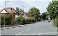
Fields Park Avenue, Newport
The view north along the western part of Fields Park Avenue, viewed from Fields Park Road.
Image: © Jaggery
Taken: 25 Jul 2010
0.02 miles
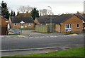
2

Ridgeway Reach bungalows, Newport
Bungalows in a cul-de-sac viewed across Ridgeway Hill.
A Ridgeway Reach name sign is on the left.
Image: © Jaggery
Taken: 2 Oct 2024
0.04 miles
3
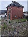
Distinctive brick building at the southern edge of Ridgeway, Newport
Set back from the corner of Ridgeway Avenue and Fields Park Road,
the building houses a National Grid electricity substation.
Image: © Jaggery
Taken: 2 Oct 2024
0.05 miles
4
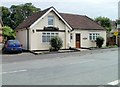
The Coach House, Fields Park Road, Newport
House located opposite the turning for Fields Park Avenue.
Image: © Jaggery
Taken: 25 Jul 2010
0.05 miles
5
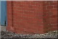
Ordnance Survey Cut Mark
This OS cut mark can be found on the Electricity Sub-station. It marks a point 75.987m above mean sea level.
Image: © Adrian Dust
Taken: 29 Dec 2019
0.05 miles
6
Ridgeway Reach, Newport
Modern bungalows, viewed from Ridgeway Hill.
Image: © Jaggery
Taken: 12 Dec 2009
0.05 miles
7
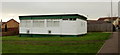
Ridgeway and Allt-yr-yn Community Centre, Newport
Set back about 20 metres from the west side of Ridgeway Hill.
Image: © Jaggery
Taken: 12 Dec 2009
0.05 miles
8
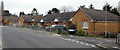
Looking up Ridgeway Hill, Newport
Bungalows on the east side of Ridgeway Hill, between Ridgeway Walk and Ridgeway Reach.
Image: © Jaggery
Taken: 12 Dec 2009
0.05 miles
9
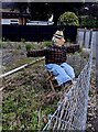
Scarecrow, Ridgeway Avenue, Newport
An entrant in the annual Ridgeway Scarecrow Festival https://www.geograph.org.uk/photo/7895383 viewed on October 2nd 2024.
Image: © Jaggery
Taken: 2 Oct 2024
0.06 miles
10

Scarecrow Festival notice, Ridgeway Avenue, Newport
On display in early October 2024 near one https://www.geograph.org.uk/photo/7895381 of the entrants
in the annual Ridgeway Scarecrow Festival.
Image: © Jaggery
Taken: 2 Oct 2024
0.06 miles