IMAGES TAKEN NEAR TO
Ridgeway Crescent, NEWPORT, NP20 5AP
Introduction
This page details the photographs taken nearby to Ridgeway Crescent, NP20 5AP by members of the Geograph project.
The Geograph project started in 2005 with the aim of publishing, organising and preserving representative images for every square kilometre of Great Britain, Ireland and the Isle of Man.

There are currently over 7.5m images from over14,400 individuals and you can help contribute to the project by visiting https://www.geograph.org.uk
Image Map
Images are licensed for reuse under creativecommons.org/licenses/by-sa/2.0
Notes
- Clicking on the map will re-center to the selected point.
- The higher the marker number, the further away the image location is from the centre of the postcode.
Image Listing (186 Images Found)
Images are licensed for reuse under creativecommons.org/licenses/by-sa/2.0
Image
Details
Distance
1
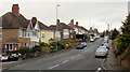
Ridgeway Avenue, Newport
Looking west from the Ridgeway Close / Ridgeway Drive junction.
Image: © Jaggery
Taken: 12 Dec 2009
0.02 miles
2
Ridgeway Drive, Newport
Looking south from Ridgeway Avenue towards Risca Road.
Image: © Jaggery
Taken: 12 Dec 2009
0.04 miles
3
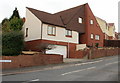
Allt yr Yn
Houses on the B4591 at Allt yr Yn.
Image: © Alan Hughes
Taken: 16 Sep 2019
0.06 miles
4
Ridgeway Close, Newport
An angular house near the Ridgeway Avenue junction.
Image: © Jaggery
Taken: 12 Dec 2009
0.06 miles
5
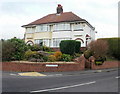
Ridgeway Hill semis, Newport
Houses on the corner of Ridgeway Hill and Ridgeway Avenue.
Image: © Jaggery
Taken: 12 Dec 2009
0.06 miles
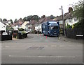
6
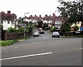
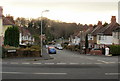
Up Ridgeway Drive, Newport
From Risca Road, Ridgeway Drive ascends into the Ridgeway area of Newport.
Image: © Jaggery
Taken: 26 Jun 2019
0.07 miles
7
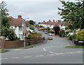
Ridgeway Drive, Newport
Viewed across Risca Road.
Image: © Jaggery
Taken: 25 Jul 2010
0.07 miles
8
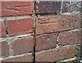
Ordnance Survey Cut Mark
This OS cut mark can be found on No36 Ridgeway Avenue. It marks a point 83.786m above mean sea level.
Image: © Adrian Dust
Taken: 29 Dec 2019
0.08 miles
9
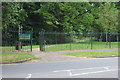
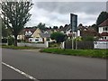
Entrance to Coed-Melin Park, Risca Road
The public footpath is part of the Sirhowy Valley Walk.
Image: © M J Roscoe
Taken: 10 Jul 2017
0.09 miles
10
Junction of Redbrook Road and Risca Road, Newport
The name sign on the right shows REDBROOK ROAD.
The name sign on the fence on the left shows RED BROOK ROAD.
Image: © Jaggery
Taken: 26 Jun 2019
0.09 miles