IMAGES TAKEN NEAR TO
Redbrook Road, NEWPORT, NP20 5AB
Introduction
This page details the photographs taken nearby to Redbrook Road, NP20 5AB by members of the Geograph project.
The Geograph project started in 2005 with the aim of publishing, organising and preserving representative images for every square kilometre of Great Britain, Ireland and the Isle of Man.

There are currently over 7.5m images from over14,400 individuals and you can help contribute to the project by visiting https://www.geograph.org.uk
Image Map
Images are licensed for reuse under creativecommons.org/licenses/by-sa/2.0
Notes
- Clicking on the map will re-center to the selected point.
- The higher the marker number, the further away the image location is from the centre of the postcode.
Image Listing (128 Images Found)
Images are licensed for reuse under creativecommons.org/licenses/by-sa/2.0
Image
Details
Distance
1
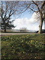
Daffodils and Snow
Daffodils growing at the corner of Ridgeway and Redbrook Road, but distant Twm Barlwm still has a covering of snow.
Image: © David Roberts
Taken: 11 Feb 2009
0.02 miles
2
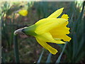
Allt-yr-yn Daffodil
An early daffodil growing Allt-yr-yn.
Image: © David Roberts
Taken: 11 Feb 2009
0.04 miles
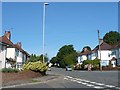
3
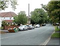
Ridgeway, Newport
Ridgeway is both an area of Newport and a residential road. This view is of the road between Ridgeway Avenue and Redbrook Road, looking in the direction of Risca Road.
Image: © Jaggery
Taken: 25 Jul 2010
0.06 miles
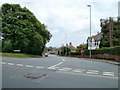
4
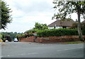
Corner of Redbrook Road, Newport
Viewed from Ridgeway. Redbrook Road descends towards Risca Road.
Image: © Jaggery
Taken: 25 Jul 2010
0.06 miles
5
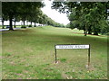
Open space, Ridgeway, Newport
Viewed from the corner of Ridgeway Avenue, this area of open space to the south of Allt-yr-yn Avenue is about 350 metres long, and 60 metres across at its widest point.
Image: © Jaggery
Taken: 25 Jul 2010
0.06 miles
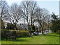
6
NW end of Ridgeway Avenue, Newport
Ridgeway Avenue heads away SE from the point where Allt-yr-yn Avenue on the left becomes Ridgeway on the right.
Image: © Jaggery
Taken: 25 Jul 2010
0.06 miles
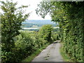
7
Ridgeway, Newport
On the outskirts of the City of Newport giving extensive views over the city to the south http://www.geograph.org.uk/photo/624906 and open countryside to the north http://www.geograph.org.uk/photo/624897 .
Image: © Robin Drayton
Taken: 1 May 2013
0.08 miles
8
Ridgeway Avenue
This is on the route of the Sirhowy Valley Walk.
Image: © Robin Drayton
Taken: 23 Aug 2007
0.09 miles
9
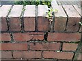
Ordnance Survey Cut Mark
This OS cut mark can be found on the wall of Cornerways, Ridgeway Avenue. It marks a point 94.595m above mean sea level.
Image: © Adrian Dust
Taken: 29 Dec 2019
0.09 miles
10
Footpath to Cwrt-y-mwnys, Newport
Accessed from Allt-yr-yn Avenue opposite Ridgeway Avenue, this is the start of a footpath that descends from Ridgeway.
Image: © Jaggery
Taken: 25 Jul 2010
0.09 miles