1
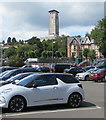
Towards the Civic Centre Clock Tower, Newport
Viewed from the car park on the west side of Newport railway station.
Image: © Jaggery
Taken: 10 Aug 2017
0.01 miles
2
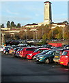
Newport Civic Centre clock tower
Viewed from Newport Railway Station Car Park near the entrance to platform 4.
Image: © Jaggery
Taken: 15 Nov 2019
0.01 miles
3
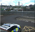
From Queensway towards Newport Civic Centre
Looking past Newport railway station towards the clock tower here. https://www.geograph.org.uk/photo/3765834
Image: © Jaggery
Taken: 6 May 2021
0.01 miles
4
Towards Newport Civic Centre from Bridge Street, Newport
Looking past railway lines near Newport station towards the clock tower here. https://www.geograph.org.uk/photo/3765834
Image: © Jaggery
Taken: 6 May 2021
0.01 miles
5
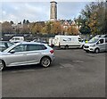
Towards Newport Civic Centre clock tower
Viewed from Newport railway station's main car park.
The tower is about 280 metres from the camera.
Image: © Jaggery
Taken: 18 Nov 2022
0.01 miles
6
Newport Civic Centre
A Grade II* listed building.
Building commenced in 1937 with an opening in 1940. Building work was suspended during WW2 with the clock tower being completed in 1964.
The area in the foreground, now being used by the construction workers of the new railway station, will eventually be used as a car park for the station http://www.geograph.org.uk/photo/1640291 .
Image: © Robin Drayton
Taken: 28 Dec 2009
0.01 miles
7
Newport Civic Centre
Because the civic centre is prominently situated on the side of a hill, it is more usually pictured from the other side. http://www.geograph.org.uk/photo/718443 However, it is this side that has the main entrance which is below the level of this car park.
Image: © Robin Drayton
Taken: 15 Sep 2008
0.02 miles
8
Towards the Civic Centre clock tower, Newport
From Devon Place towards the clock tower http://www.geograph.org.uk/photo/969665
located on higher ground 230 metres away.
Image: © Jaggery
Taken: 21 May 2017
0.02 miles
9
Clock tower of Newport Civic Centre
A view of the clock tower of Newport Civic Centre taken from Newport Train station
Image: © Gail Franklin
Taken: 27 Nov 2010
0.02 miles
10
Newport Civic Centre
This view is taken from
Image Construction was started in 1937 and the building was partly completed before WW2. The clock tower was added in the 1960s.
Image: © Robin Drayton
Taken: 4 Mar 2008
0.02 miles


