IMAGES TAKEN NEAR TO
Clytha Park Road, NEWPORT, NP20 4TU
Introduction
This page details the photographs taken nearby to Clytha Park Road, NP20 4TU by members of the Geograph project.
The Geograph project started in 2005 with the aim of publishing, organising and preserving representative images for every square kilometre of Great Britain, Ireland and the Isle of Man.

There are currently over 7.5m images from over14,400 individuals and you can help contribute to the project by visiting https://www.geograph.org.uk
Image Map
Images are licensed for reuse under creativecommons.org/licenses/by-sa/2.0
Notes
- Clicking on the map will re-center to the selected point.
- The higher the marker number, the further away the image location is from the centre of the postcode.
Image Listing (1035 Images Found)
Images are licensed for reuse under creativecommons.org/licenses/by-sa/2.0
Image
Details
Distance
1
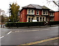
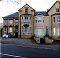
Clytha Clinic, Newport
Dental clinic, 27 Clytha Park Road.
Image: © Jaggery
Taken: 15 Nov 2015
0.01 miles
2
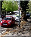
20 sign on a Clytha Park Road lamppost, Newport
Viewed in May 2021. This is one of many roads in Newport where the 30mph speed limit was reduced to 20mph earlier this year.
Image: © Jaggery
Taken: 6 May 2021
0.01 miles
3
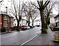
Tree-lined Clytha Park Road, Newport
Few leaves remain on the trees in mid November 2015.
A summertime satellite view of this area shows little more than a green leafy canopy.
Image: © Jaggery
Taken: 15 Nov 2015
0.02 miles
4
Faulkner Road, Newport
Houses on the south side of Faulkner Road. The north side of Faulkner Road is part of the Civic Centre carpark.
Image: © Jaggery
Taken: 10 Dec 2009
0.02 miles
5
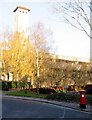
King George VI pillarbox near Newport Civic Centre
Viewed across Faulkner Road.
The low angle of the early morning sun gives the Civic Centre clock tower a ghostlike appearance.
Image: © Jaggery
Taken: 21 Nov 2015
0.02 miles
6
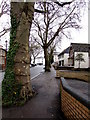
Tree-edged pavement, Clytha Park Road, Newport
On the south side of Clytha Park Road, between Llanthewy Road and Caerau Road (ahead).
Image: © Jaggery
Taken: 15 Nov 2015
0.02 miles
7
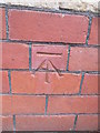
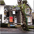
Ordnance Survey Cut Mark
This OS cut mark can be found on the Old Clinic building to the NE of Clytha Park Road. It marks a point 24.492m above mean sea level.
Image: © Adrian Dust
Taken: 25 May 2015
0.02 miles
8
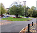
Tree on a grassy roundabout, Newport
The roundabout is the middle of the Clytha Park Road, Faulkner Road and Llanthewy Road junctions.
The Civic Centre clock tower is in the background.
Image: © Jaggery
Taken: 14 Oct 2018
0.03 miles
9
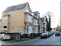
Victoria Chambers, 11 Clytha Park Road, Newport
The name VICTORIA CHAMBERS is over the entrance doorway on the left.
COLBORNE COULMAN & LAWRENCE Solicitors is on the window behind the car.
Image: © Jaggery
Taken: 21 Nov 2015
0.03 miles
10
1 to 1 Accountancy Services, Newport
Office in Clytha House, 10 Clytha Park Road.
Image: © Jaggery
Taken: 15 Nov 2015
0.03 miles