IMAGES TAKEN NEAR TO
Edward VII Avenue, NEWPORT, NP20 4TL
Introduction
This page details the photographs taken nearby to Edward VII Avenue, NP20 4TL by members of the Geograph project.
The Geograph project started in 2005 with the aim of publishing, organising and preserving representative images for every square kilometre of Great Britain, Ireland and the Isle of Man.

There are currently over 7.5m images from over14,400 individuals and you can help contribute to the project by visiting https://www.geograph.org.uk
Image Map
Images are licensed for reuse under creativecommons.org/licenses/by-sa/2.0
Notes
- Clicking on the map will re-center to the selected point.
- The higher the marker number, the further away the image location is from the centre of the postcode.
Image Listing (175 Images Found)
Images are licensed for reuse under creativecommons.org/licenses/by-sa/2.0
Image
Details
Distance
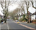
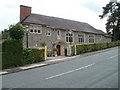
1
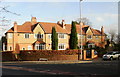
Edward VII Crescent, Newport
Houses at the Edward VII Avenue end of Edward VII Crescent.
Image: © Jaggery
Taken: 12 Dec 2009
0.03 miles
2
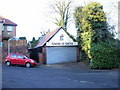
Edward VII Garage (North), Newport
Located at the Westfield Road end of Edward VII Crescent, opposite Edward VII Garage (South). http://www.geograph.org.uk/photo/1631024
Servicing, repairs, welding, MOT preparation.
Image: © Jaggery
Taken: 20 Dec 2009
0.03 miles
3
Edward VII Garage (South), Newport
Located at the Westfield Road end of Edward VII Crescent, opposite Edward VII Garage (North). http://www.geograph.org.uk/photo/1630999
Servicing, repairs, welding, MOT preparation
Image: © Jaggery
Taken: 20 Dec 2009
0.03 miles
5
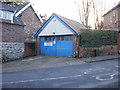
Edward VII Garage
Junction of Edward VII Crescent and Westfield Road. A small workshop situated in an area of large, detached, Victorian houses.
Image: © Robin Drayton
Taken: 18 Dec 2009
0.04 miles
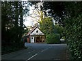
6
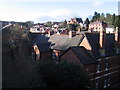
Edward VII Avenue, Newport
Looking up Edward VII Avenue from the Edward VII Crescent junction.
Image: © Jaggery
Taken: 12 Dec 2009
0.05 miles
7
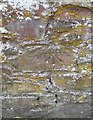
Ordnance Survey Cut Mark
This OS cut mark can be found on the wall SE side of Fields Road. It marks a point 54.964m above mean sea level.
Image: © Adrian Dust
Taken: 17 Jun 2018
0.06 miles
8
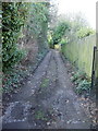
Edward VII Lane, Newport
Viewed from Fields Road.
Image: © Jaggery
Taken: 12 Dec 2009
0.06 miles
9
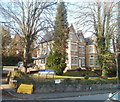
Pardoeham Hall, Newport
The large (about 30 metres long by 15 metres wide) building in Fields Park Road was built in 1913, probably for the Pardoe-Thomas family who were in the shipping business in South Wales. Leslie Pardoe-Thomas was sometime mayor of Newport.
I am grateful to Luke Fussell for telling me the year of construction.
Image: © Jaggery
Taken: 25 Jul 2010
0.06 miles
10
Tredegar Constitutional Club, Newport
Located on the corner of Oakfield Road and Parkfield Place.
Image: © Jaggery
Taken: 2 Mar 2011
0.08 miles