IMAGES TAKEN NEAR TO
Faulkner Road, NEWPORT, NP20 4PR
Introduction
This page details the photographs taken nearby to Faulkner Road, NP20 4PR by members of the Geograph project.
The Geograph project started in 2005 with the aim of publishing, organising and preserving representative images for every square kilometre of Great Britain, Ireland and the Isle of Man.

There are currently over 7.5m images from over14,400 individuals and you can help contribute to the project by visiting https://www.geograph.org.uk
Image Map
Images are licensed for reuse under creativecommons.org/licenses/by-sa/2.0
Notes
- Clicking on the map will re-center to the selected point.
- The higher the marker number, the further away the image location is from the centre of the postcode.
Image Listing (864 Images Found)
Images are licensed for reuse under creativecommons.org/licenses/by-sa/2.0
Image
Details
Distance
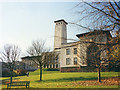
1
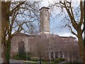
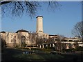
Newport Civic Centre and Crown Court
This building had three distinct phases of construction.
On the 14th July 1937, just two months after the coronation, King George VI, accompanied by Queen Elizabeth, used a silver spade to cut the first sod for a new Civic Centre. This was the building in the rear which, minus the clock tower, was opened in 1940.
Due to the war, work on the clock tower had to be suspended and it was not until September 1963 that the Council, not without controversy, agreed to continue with this work.
Later, towards the end of the 20th century, a building to house the Crown Court was constructed in front of the original building.
Image: © Robin Drayton
Taken: 4 Mar 2017
0.00 miles
2
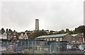
Civic Buildings, Newport
View of Civic Buildings in Newport from the railway line.
Image: © Alan Hughes
Taken: 27 Oct 2016
0.01 miles
3
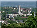
Newport Civic Centre
Viewed from the top of Newport Cathedral tower http://www.geograph.org.uk/photo/716275 .
Image: © Robin Drayton
Taken: 4 Jul 2011
0.02 miles
4
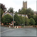
Tree-lined privacy, Devon Place, Newport
Trees shield offices on the corner of Devon Place and Godfrey Road from prying eyes. In the distance is the tower of St Mark's Church. http://www.geograph.org.uk/photo/801996
Image: © Jaggery
Taken: 21 Aug 2010
0.02 miles
5
Newport: Civic Centre
One of the most prominent buildings in the city, I am surprised it has lasted this long without being represented on this website!
Image: © Chris Downer
Taken: 17 Feb 2008
0.02 miles
6
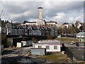
Newport: the Civic Centre from Railway Street
The distinctive tower of Image, catching the morning sunlight to good effect. In the foreground, we see Railway Street emerging onto Queensway.
Image: © Chris Downer
Taken: 1 Feb 2010
0.02 miles
7
Newport: the Civic Centre from the Bridge Street bridge
Looking across industrial ground abutting the railway station, with the Image clock tower looming large over the frontages of Godfrey Road.
Image: © Chris Downer
Taken: 1 Mar 2014
0.02 miles
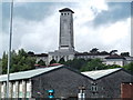
8

Newport City Council tower from the railway
Image: © Roy Hughes
Taken: 17 Aug 2019
0.03 miles
9
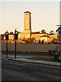
Newport Crown Court
Clock tower of the court buildings as seen from Newport Station
Image: © Eirian Evans
Taken: 2 Aug 2014
0.03 miles
10
Newport Civic Centre (1987)
Changes since this photo was taken are that the area in front of the buildings is now a car park and that Newport Crown Court occupies the area to the left in front of the clock tower. For a later picture see https://www.geograph.org.uk/photo/5678041 .
Image: © Robin Drayton
Taken: Unknown
0.03 miles