IMAGES TAKEN NEAR TO
Fields Road, NEWPORT, NP20 4PJ
Introduction
This page details the photographs taken nearby to Fields Road, NP20 4PJ by members of the Geograph project.
The Geograph project started in 2005 with the aim of publishing, organising and preserving representative images for every square kilometre of Great Britain, Ireland and the Isle of Man.

There are currently over 7.5m images from over14,400 individuals and you can help contribute to the project by visiting https://www.geograph.org.uk
Image Map
Images are licensed for reuse under creativecommons.org/licenses/by-sa/2.0
Notes
- Clicking on the map will re-center to the selected point.
- The higher the marker number, the further away the image location is from the centre of the postcode.
Image Listing (954 Images Found)
Images are licensed for reuse under creativecommons.org/licenses/by-sa/2.0
Image
Details
Distance
1

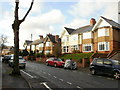
On-street parking, Fields Road, Newport
Long line of parked cars on the north side of Fields Road, viewed from the corner of Serpentine Road.
Image: © Jaggery
Taken: 17 Aug 2016
0.01 miles
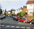
2
St Mark's Crescent, Newport
Houses on the north side of St Mark's Crescent, near the junction with Queen's Hill Crescent.
Image: © Jaggery
Taken: 10 Dec 2009
0.02 miles
3

Chrome Blue Physiotherapy Clinic, Newport
The clinic is on the right, at 17 Gold Tops.
Image: © Jaggery
Taken: 12 Jun 2014
0.03 miles
4

Scaffolding on 15 Gold Tops, Newport
In June 2014 the former office building was being converted to four 2-bedroom apartments.
Image: © Jaggery
Taken: 12 Jun 2014
0.03 miles
6
St Mark's Crescent, Newport
Houses on the east side of St Mark's Crescent, viewed from the corner of Fields Road and Serpentine Road.
Image: © Jaggery
Taken: 10 Dec 2009
0.05 miles
7
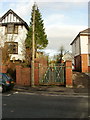
Former school entrance, St Mark's Crescent, Newport
Several decades ago, this was a side entrance to what was at that time a grammar school, Newport High School. The rusting gates and overgrown vegetation along the path suggest that this entrance is now disused.
Image: © Jaggery
Taken: 10 Dec 2009
0.05 miles
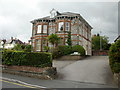
8
6 Gold Tops, Newport
The view from Gold Tops. See http://www.geograph.org.uk/photo/1614179 for the side view from Serpentine Road, and details of the occupiers.
Image: © Jaggery
Taken: 12 Dec 2009
0.05 miles
9
Corner of St Marks Crescent and Fields Road, Newport
The eastern corner of St Marks Crescent and Fields Road, viewed from Serpentine Road.
Image: © Jaggery
Taken: 25 Jul 2010
0.05 miles
10

Vacant former Register Office, Newport
Viewed across Gold Tops in June 2014. Boards cover windows of the city's
former Register Office, which has been in Mansion House http://www.geograph.org.uk/photo/2522595 since July 1st 2011.
The Civic Centre clock tower is in the background.
Image: © Jaggery
Taken: 12 Jun 2014
0.05 miles