IMAGES TAKEN NEAR TO
Godfrey Road, NEWPORT, NP20 4NX
Introduction
This page details the photographs taken nearby to Godfrey Road, NP20 4NX by members of the Geograph project.
The Geograph project started in 2005 with the aim of publishing, organising and preserving representative images for every square kilometre of Great Britain, Ireland and the Isle of Man.

There are currently over 7.5m images from over14,400 individuals and you can help contribute to the project by visiting https://www.geograph.org.uk
Image Map
Images are licensed for reuse under creativecommons.org/licenses/by-sa/2.0
Notes
- Clicking on the map will re-center to the selected point.
- The higher the marker number, the further away the image location is from the centre of the postcode.
Image Listing (1277 Images Found)
Images are licensed for reuse under creativecommons.org/licenses/by-sa/2.0
Image
Details
Distance
1
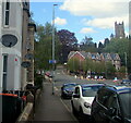
Godfrey Road satellite dishes, Newport
The tower of St Mark's Church is in the background.
Image: © Jaggery
Taken: 6 May 2021
0.01 miles
2
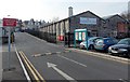
Exit road from Newport railway station car park
Looking towards Godfrey Road. The Pay and Display car park,
operated by National Car Parks Ltd, has space for 246 cars.
Image: © Jaggery
Taken: 5 Mar 2013
0.01 miles
3
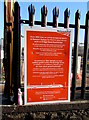
Network Rail notice facing Godfrey Road, Newport
On railings near this http://www.geograph.org.uk/photo/5306729 Network Rail construction site. The notice is in English and Welsh.
The English text states
From 30th June (2016) we will be occupying spaces in Newport Station
Car Park to carry out our work on Bridge Street Road Bridge.
We will be setting up a site compound and positioning a large crane on the car park beneath the bridge.
We kindly ask all passengers who drive to the station to allow extra time to park.
Thank you for bearing with us while we build a better railway for South Wales.
Image: © Jaggery
Taken: 1 Dec 2016
0.02 miles
4
Entrance to Godfrey Road Pay & Display Car Park, Newport
NCP long stay car park near Newport railway station. Signs show maximum speed 5 (mph). The tower of St Mark's Church is in the background.
Image: © Jaggery
Taken: 6 May 2021
0.02 miles
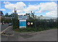
5
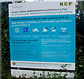
Car park information board, Godfrey Road, Newport
Information on display here https://www.geograph.org.uk/photo/6911048 includes
"No heavy goods vehicles" and "No buses".
The text is in English and Welsh.
Image: © Jaggery
Taken: 6 May 2021
0.02 miles
7
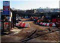
Network Rail construction site entrance, Newport
From Godfrey Road. The site occupies park of Newport Station Car Park during work to replace Bridge Street road bridge over the South Wales Main Line.
Image: © Jaggery
Taken: 1 Dec 2016
0.02 miles
8
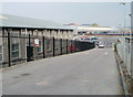
Entrance to Godfrey Road car park, Newport
The 246-space car park on the west side of Newport railway station is operated by National Car Parks Ltd.
Image: © Jaggery
Taken: 29 Apr 2011
0.02 miles
9
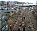
Southern approach to Newport railway station
Viewed from the Bridge Street bridge. http://www.geograph.org.uk/photo/2644795
At the trackside in front of the signal gantry, a small yellow milepost shows 158¾ miles (to Paddington). This was the distance before the opening of the Severn Tunnel to passenger traffic in December 1886. The route via the tunnel is about 30 miles shorter.
Image: © Jaggery
Taken: 2 Mar 2012
0.02 miles
![A new gateway for Wales [1]](https://s3.geograph.org.uk/geophotos/01/64/02/1640255_2dd3646c_120x120.jpg)